The Eye of the Sahara and Atlantis
The Richat Structure, Guelb er Richât in Arabic and often called the Eye of the Sahara, is a dome at least 40 km across on the Adrar plateau of Mauritania. Its sedimentary beds, Late Proterozoic to Ordovician in age, dip outward, and erosion has picked out the harder ones as three nested rings of ridges around a centre of breccia and igneous rock[1]. Space crews have used it as a landmark since the Gemini missions of the 1960s; NASA puts it at about 45 km across[1][2].
It was first taken for a meteorite crater. Work in the 1960s found no sign of impact, and the coesite once reported from it turned out to be a misidentification[3][4]. In 2005 Matton, Jébrak and Lee showed it to be the top of a buried alkaline igneous complex: carbonatite dated to 99 ± 5 million years, and feldspar grown in the central breccia to 98.2 ± 2.6 million years, when hot fluids dissolved the limestone at the summit of the dome and its roof collapsed[1][5]. A 2024 study argues that its two gabbro rings are older sills, of about 230 to 200 million years ago, that the later intrusion bent into the dome[6].
The outer ring holds one of the largest accumulations of early stone tools in the Sahara, pebble tools and Acheulean handaxes left by hunter-gatherers in wetter phases of the Pleistocene. None has yet been dated[7][8].
Since at least 2006 the structure has been put forward as the capital of Atlantis, the island city Plato described in the Timaeus and Critias, ringed by belts of sea and land and swallowed by the sea in a single day and night[9][10][11]. A YouTube video by Bright Insight made the idea famous in September 2018[12][13]. Against it: the rings are a natural landform some 100 million years old, the structure stands about 485 m above sea level some 500 km from the coast, and no trace of a city has been found on it[14][2][15].
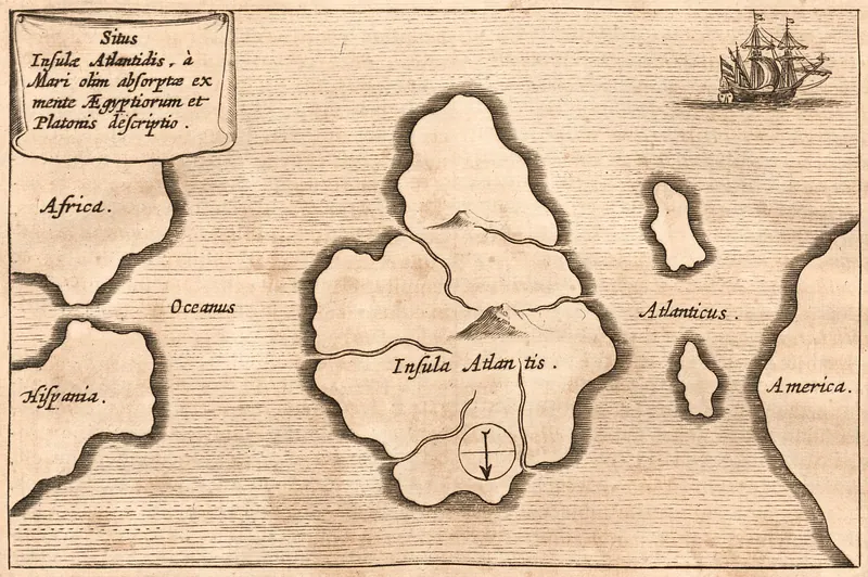
The Sahara around it was green, with streams and small lakes, between about 14,800 and 5,500 years ago[16][17], but no ancient writer reviewed here puts Plato's Atlantis in Africa, and the earliest drawn map of it found, Kircher's of 1665, puts it in the open Atlantic[18]. Of the 9 questions on this site, 0 are answered.
Key questionsset by the editors
The site
The structure lies in the north-west of the Taoudenni basin, in the middle of the Mauritanian Adrar plateaus, where it shows at the surface as a slightly elliptical depression about 40 km across, ringed by ridges[19]. The rocks are a Late Proterozoic to Ordovician sequence of sandstone, limestone, dolomite and mudstone. They dip outward at 10 to 20 degrees, and erosion has cut the resistant quartzite beds into three nested cuestas[1] that stand 20 to 30 m above the hollows between them[5]. The plateau around the structure stands about 200 m above the desert sand, the outer rim reaches about 485 m above sea level, and sand is spreading onto its southern side[14].
At the centre a shelf of limestone and dolomite encloses a siliceous breccia about 3 km across and at least 40 m thick. Basalt ring dikes, carbonatite dikes, kimberlite and alkaline volcanic rocks cut the dome and are not found outside it. The outer ring dike, about 50 m wide, lies 7 to 8 km from the centre; the inner, about 20 m wide, about 3 km[1]. Two rhyolite centres are the eroded remains of maars, craters left by steam explosions[5].
Geologists have argued over its origin since the 1950s[19]. Space crews have photographed it since the Gemini missions[1]; the picture at the head of this page was taken from the International Space Station on 17 December 2011[2]. The International Union of Geological Sciences lists it as a geological heritage site, a concentric alkaline magmatic complex[19]. The caravan town of Ouadane, one of four ksour founded in the 11th and 12th centuries for the trans-Saharan trade and on the World Heritage List since 1996, lies to the south-west[20].
Timeline
What was found
Théodore Monod found accumulations of pre-Acheulean and Acheulean tools in the depression of the outer ring, along Wadi Akerdil and Wadi Bamouéré, beside outcrops of Chinguetti quartzite that supplied the stone[21][8]. Robert Vernet calls the Richât, east of Ouadane, probably the largest concentration of pebble tools in the Sahara. More than 100 pebble tools at Akerdil were drawn where they lay in 1982. In 1999 G. Prince found a site, named after Monod, with 113 fresh artefacts, mostly choppers and flakes, in a sandy palaeosol; a refit and the evenness of the knapping led him to judge it undisturbed and older than the early Acheulean[7].
Missions under Henry de Lumley worked in the Adrar from 1999 to 2006. Vernet notes that they produced publications but no study of the material, no substantial stratigraphy and no absolute dates[7]. Their sediment study dated the torrential alluvium of the outer ring: eleven AMS radiocarbon dates on shells and calcite cements fall between about 15,000 and 7,730 years BP, in the African Humid Period, and palaeomagnetism places most of the deposits in the present normal-polarity epoch, so older Pleistocene sediment is unlikely to survive on the slopes. The authors read the large tools as made on the spot, concentrated by wind erosion and then cemented by calcite, and expect more to lie buried in the outer alluvial plain[8].
Later people left engravings. At Tililit, in the Richat, they are of several styles or periods: elephants, giraffes, ostriches, antelopes, cattle, armed men, horsemen, a stylised chariot and Libyco-Berber inscriptions. Chariots are engraved at Oued Tenzer on the eastern edge. None is dated[22]. No walls, houses, pottery or engineering works have been reported from the structure[15][23].
What is known
The origin of the structure is settled in outline. It is an eroded dome raised by an igneous intrusion; its rings are the edges of resistant beds, not built or dug features. Magnetic and gravity models show circular anomalies on the gabbro ring dykes above a deep mafic body and favour an intrusion over an impact[24]. The carbonatite and the hydrothermal breccia are Cretaceous, about 99 and 98 million years old[1]. What is not settled is the age of the gabbros. Matton and Jébrak read them as part of one complex, inferring 104 to 94 million years for the whole suite[5]. Abdeina and colleagues obtained no robust age from them, but their modelling and chemistry point to sills of the Central Atlantic Magmatic Province, 230 to 200 million years old, domed about 100 million years later[6].
Plato's Timaeus and Critias are the only independent source for Atlantis; every later ancient account found for this review goes back to him. In the Timaeus the island lies in the ocean in front of the Pillars of Heracles, larger than Libya and Asia together; its kings held Libya as far as Egypt; after a war with Athens it was swallowed by the sea in one grievous day and night, leaving a shoal of mud[11]. In the Critias Poseidon cuts belts of sea and land around Cleito's hill, two of land and three of sea. Their widths are 3, 3, 2, 2 and 1 stades around an island 5 stades across, and a wall runs 50 stades beyond the largest ring. Around the city is a plain of 3,000 by 2,000 stades that faces south, is sheltered from the north by mountains, and is enclosed by a ditch 10,000 stades long. The island had a great many elephants[10]. The translator gives the stade as about 600 feet, so the rings and island together, 27 stades, come to about 5 km[10].
Readers in antiquity disagreed about whether it was true. Strabo praises Posidonius for allowing that the story may not be fiction, rather than saying that "its inventor caused it to disappear, just as did the Poet the wall of the Achaeans"[25]; elsewhere Strabo gives that remark about the wall as Aristotle's, so read together the two passages make the sceptic Plato's own pupil[26]. Proclus, writing in the fifth century AD, says that Crantor, the first commentator on Plato, took the story as plain history, and cites Marcellus's Ethiopic History for islands in the outer sea whose people remembered the Atlantic island[27]. Plutarch has Solon hear the story from priests of Heliopolis and Saïs and leave his poem on it unfinished, and Plato die before finishing his own[28]. Philo, Pliny, Tertullian, Arnobius and Ammianus repeat it as land or an island swallowed by the Atlantic; Philo and Tertullian measure it against Africa and Asia, and Pliny adds "if we are to believe Plato"[29][30][31][32][33]. Aelian preserves a tale by Theopompus of a continent beyond the ocean and its people the Meropes, and calls its author "an egregious Romancer"[34].
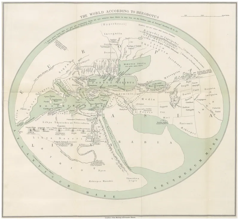
Two ancient texts tie names like Atlantis to north-west Africa, and neither is about Plato's island. Herodotus, a generation before Plato, puts a people called the Atlantes on the salt ridge of inner Libya, named after Mount Atlas, which the people there call "the pillar of heaven"; beyond the ridge, which runs to the Pillars of Heracles, Libya is desolate and waterless, without rain or forest[35]. Diodorus, in the first century BC, tells of the Atlantians, the most civilised people of western Libya, living by the ocean near Mount Atlas, who were conquered by Amazons from the island Hespera in the marsh Tritonis; the marsh later vanished in an earthquake. His Loeb editor traces the story to a mythical romance by Dionysius Skytobrachion of the mid-second century BC[36]. Where Lake Tritonis lay was disputed in antiquity: the Herodotean tradition points to the Gulf of Gabès, other writers to the Lesser Syrtis, between the Syrtes or Cyrenaica, and only Mela, and perhaps Ptolemy, to an inland lake such as the great Tunisian chotts[37]. Pliny calls Mount Atlas "the most fabulous locality even in Africa"[38].
No map of Atlantis survives from Greek or Roman antiquity; every ancient account is prose. The earliest drawn map of Atlantis found for this review is Athanasius Kircher's of 1665. It sets the island in the middle of the Atlantic between Africa and Spain on one side and America on the other, with south at the top[18]. The nearest thing to a Greek map of the region is a modern reconstruction of the world Herodotus described. It marks the Atlantes, Mount Atlas and the ridge running to the Pillars, and has no Atlantis[39].
Most archaeologists and classical philologists read Atlantis as Plato's invention, a story made to carry his argument about the ideal state[40]. Alan Cameron calls it "virtually demonstrable" that Plato made the story up, and argues that neither Crantor nor Posidonius shows that ancient readers believed it[41]. Christopher Gill reads it as the earliest narrative fiction in Greek literature[42][43]; Pierre Vidal-Naquet treats it as a fiction made to say something about the Athenian state and traces how later writers reused it[44]; Heinz-Günther Nesselrath's 2002 lecture is titled Plato and the Invention of Atlantis[45].
The Sahara was not always desert. A dust record off Cap Blanc, Mauritania, shows the African Humid Period between about 14,800 and 5,500 years ago, when the Sahara was "nearly completely vegetated" and held "numerous perennial lakes". An arid interval matching the Younger Dryas interrupts it, and both its start and its end took only decades to centuries[16]. A synthesis of records across Africa gives the same span and finds that the end, abrupt in places, came later the nearer a site lay to the equator[46]. Leaf waxes in cores off the western Sahara put the Green Sahara at about 11,000 to 5000 years ago, with rain reaching 31°N and a drier pause about 8000 years ago[47]. In the eastern Sahara the drying was gradual, with desert by about 2700 years ago[48]. In wet phases rivers, lakes and inland deltas joined into networks across the desert[49], and large rivers reached the Mauritanian coast[50]. Such green phases have come and gone more than 230 times in 8 million years[51]. In the Adrar itself, small diatom lakes stood on a wadi floodplain at Tamga between 9630 and 7550 radiocarbon years BP[17], and the outer-ring sediments of the Richat, of 15,000 to 7,730 BP, are torrential stream alluvium[8]. Vernet judges that the Sahara was probably empty of people during the last glacial maximum, between about 28,000 and 11,500 calibrated years BP[7]. World sea level then stood as much as 134 m below today's and was still rising through the Younger Dryas and on to about 8,200 years ago[52].
The explanations
The Richat is the latest of several attempts to find Atlantis in Africa. In 1883 Étienne-Félix Berlioux identified it with the land of the Moroccan Atlas, putting its capital where the Sous valley once held water[53]. After his West African expedition of 1908 to 1910, Leo Frobenius argued that Atlantis had a sphere of influence reaching North Africa and that "the greater Atlantis" could still be found[54]. Pierre Benoit's novel L'Atlantide (1919) put a surviving Atlantis in the Ahaggar and gave its characters "the hypothesis of the Saharan sea" to argue over[55]. In 1927 Paul Borchardt, after Butavand, placed Atlantis between the Chott el Djerid and the Gulf of Gabès and put the Pillars of Heracles at a temple of Hercules at Gabès; Albert Herrmann then identified the Chott el Djerid with both Lake Tritonis and Atlantis, dated it to the 13th or 14th century BC and cut Plato's figures by a factor of thirty[56][57]. Sarantitis's Pillars at the Gulf of Gabès are in the same place as Borchardt's[58].
The Atlantis reading began with George S. Alexander and Natalis Rosen, who noticed the likeness to Plato's city in 2006, visited the structure in 2008 and put a film of it online in 2010[9]. George Sarantitis made the same identification at an Atlantis conference in 2008, moving Plato's Pillars of Heracles to the Gulf of Gabès and dating Atlantean wars to 9600 and 8600 BC; books by Carlos Bisceglia (2021) and David Edwards (2022) followed[58]. The idea reached a mass audience in September 2018, when a video by Jimmy Corsetti's channel Bright Insight passed half a million views in two days and was picked up by the press[12][13].
At its strongest the case runs like this. The Richat is a great set of concentric rings, and Plato's city was a set of rings around a central island. Add Plato's rings and island (27 stades) to the wall 50 stades beyond them on either side and the city is 127 stades across, about 23.5 km, which is the diameter of the Richat's main rings on Google Maps. There are uplands to the north and open ground to the south, as Plato's plain faced south and was sheltered from the north. The video dates the destruction to about 11,600 years ago, at the Younger Dryas[12][23][13]. Rivers did cross western Mauritania in humid periods[50], elephants are engraved in the Richat itself[22], and Corsetti has argued that salt in the structure shows the sea once covered it[59].
Each match has a reply from specialists. The rings are ridges of tilted rock exposed by erosion of a dome about 100 million years old, not dug channels of water[1], and they are neither complete nor discrete[23]. The structure is at least 40 km across and NASA gives 45 km, so 127 stadia matches only an inner ring and only by ignoring the outermost[2][15]; Plato's rings and island alone would span about 5 km[10]. His plain of 3,000 by 2,000 stades with its 10,000-stade ditch has no counterpart on the ground, and the ocean lies west of the Richat, not south[10][23]. The Mauritanian rivers were natural drainage to the Atlantic coast[50]. Elephants are no clue to place: Herodotus, a generation before Plato, already put them in western Libya[60], and the Tililit engravings are undated and include horsemen and a chariot[22].
The sinking is the hardest part to fit. Plato's island was swallowed by the sea[11]; the Richat's rim stands about 485 m above sea level some 500 km inland[14][2]. Twelve thousand years ago world sea level was lower than today, not higher[52], and the dated sediments of the outer ring from that time are stream and wind deposits[8]. The Younger Dryas lasted about 1,200 years and was felt mostly at high northern latitudes[23]. Plato also puts Atlantis outside Libya, in the Atlantic beyond the Pillars of Heracles, with Libya among the lands it ruled[11]. On the ground there are Palaeolithic stone tools and undated rock art, but no city, walls, pottery or canal[8][15].
The climate argument is the strongest of the matches, and it is partly right. Plato's Egyptian priest tells Solon that Athens was founded 9,000 years before, which puts the war at about 9600 BC, some 11,600 years ago[11]. That falls inside the African Humid Period as the Mauritanian dust record dates it[16][46], and streams were laying down gravel in the Richat's outer ring across that span[8]. The Richat was a wetter place within human memory. What the record shows, though, is streams and small lakes, not a sea or a ring lake. The dated deposits in the rings are torrential alluvium[8]; the nearest dated lake beds found for this review are small floodplain lakes in the south-east Adrar[17]; and Plato's rings were belts of sea joined to the ocean by a channel, not a lake fed by rivers[10]. The Younger Dryas, to which the 2018 video ties the destruction[23], is an arid break in the Mauritanian record[16], and one leaf-wax record does not start the Green Sahara until about 11,000 years ago[47]. The wet phase also went on for thousands of years after Plato's date, ending about 5,500 years ago[46], and by Herodotus's day inner Libya was known as waterless[35]. Green phases have recurred hundreds of times[51], so a wet Sahara at Plato's date is not in itself a sign of a link.
Nor does any ancient writer reviewed here put Plato's Atlantis on the African mainland. Those who repeat the story set it in or under the Atlantic[29][30][31][33], and those who took it as history looked for traces in the outer sea[27]. The Atlantes of Herodotus are a people named after Mount Atlas[35]. Diodorus's Atlantians come closest to a North African Atlantis, a civilised people by the ocean beside a marsh lost to an earthquake, but his source was a romance written two centuries after Plato, he never links them to Plato's island, and the ancients could not agree where Tritonis was[36][37]. Kircher's map, the earliest found, puts Atlantis in the open ocean[18].
Two readings of the geology itself remain in play. The impact-crater reading, based on the shape and a reported coesite, is ruled out[4][3]. Within the igneous reading, the gabbro rings may belong to the Cretaceous complex[5] or be older sills folded by it[6]; an early mapping of them as subvertical dikes sits awkwardly with the sill model[1].
Published claims
| Year | Who | Claimed | Status | Reason |
|---|---|---|---|---|
| 5th c. BC | Herodotus[35] | Beyond the salt ridge that runs to the Pillars of Heracles, inner Libya is desolate and waterless; the Atlantes, named after Mount Atlas, live on the ridge. | Accepted | The Sahara's last humid period had ended by about 5,500 years ago[46]; the Atlantes are a people, not an island[35]. |
| 4th c. BC | Plato[11] | Atlantis, an island in the Atlantic beyond the Pillars, larger than Libya and Asia, ruled Libya as far as Egypt and sank in a day and a night 9,000 years before Solon; it is "genuine history". | Disputed | Most classicists read it as Plato's own fiction[41][42][40]. |
| 4th c. BC | Theopompus (in Aelian)[34] | Beyond the ocean lies a vast continent with the cities Machimus and Eusebes, whose people, the Meropes, once crossed the ocean with a huge army. | Disputed | Known only from Aelian, who calls Theopompus "an egregious Romancer"[34]. |
| 4th c. BC | Aristotle (in Strabo)[25] | Plato invented Atlantis and then made it disappear, as Homer did the Achaean wall. | Most likely | Matches the modern reading[41][42]; the attribution rests on reading Strabo 2.3.6 with 13.1.36[26]. |
| 4th–3rd c. BC | Crantor (in Proclus)[27] | The Atlantis story is plain history. | Disputed | Cameron argues that Crantor cannot be used as evidence of ancient belief[41]. |
| 2nd c. BC | Dionysius Skytobrachion (in Diodorus)[36] | The Atlantians, the most civilised people of western Libya, lived by the ocean near Mount Atlas and the marsh Tritonis, which vanished in an earthquake. | Disputed | The Loeb editor calls Diodorus's source a mythical romance[36]; the ancients disagreed where Tritonis lay[37]. |
| 1st c. BC | Posidonius (in Strabo)[25] | The Atlantis story may not be a fiction. | Disputed | Strabo approves the caution; Cameron argues Posidonius cannot be counted a believer[41]. |
| 1st c. AD | Philo of Alexandria[29] | The island of Atlantis, greater than Africa and Asia, was overwhelmed by the sea in one day and night. | Disputed | Cites Plato's Timaeus as its authority and adds nothing independent[29]. |
| 1st c. AD | Pliny the Elder[30] | The sea carried off an immense land where the Atlantic now lies, "if we are to believe Plato". | Disputed | Pliny gives Plato as his only authority, with a caveat[30]. |
| 1st–2nd c. AD | Plutarch[28] | Solon heard the story from Egyptian priests and began a poem on it; Plato elaborated it and died before finishing. | Disputed | Plutarch says he follows Plato and is not an independent witness[28]. |
| 2nd c. AD | Tertullian[31] | A region larger than Asia or Africa was seized by the Atlantic Ocean. | Disputed | Gives Plato as his authority[31]. |
| 4th c. AD | Arnobius[32] | Ten thousand years ago a host from the island of Atlantis destroyed countless peoples. | Disputed | Gives Plato as his authority[32]. |
| 4th c. AD | Ammianus Marcellinus[33] | An earthquake swallowed an island larger than Europe in the Atlantic Ocean. | Disputed | An example in a digression on earthquakes, from Plato's story[33]. |
| 5th c. AD | Marcellus (in Proclus)[27] | Islands in the outer sea, sacred to Proserpine, Pluto, Ammon and Neptune, kept a memory of the Atlantic island. | Disputed | Known only from Proclus's citation of a lost Ethiopic History[27]. |
| 1665 | Athanasius Kircher[18] | Atlantis was a great island in the middle of the Atlantic between Africa and Spain and America (map). | Disputed | A seventeenth-century drawing whose title says it follows "the Egyptians and Plato"[18]. |
| 1883 | Étienne-Félix Berlioux[53] | Atlantis was the land of the Moroccan Atlas, its capital in the once-flooded Sous valley. | Disputed | Plato puts Atlantis in the Atlantic beyond the Pillars[11], and no ancient source reviewed here puts it in Africa. |
| 1911 | Leo Frobenius[54] | Atlantis's influence reached North Africa, and "the greater Atlantis" can still be found in West Africa. | Disputed | An argument from the cultures he recorded on his 1908 to 1910 expedition[54]; no ancient source reviewed here puts Atlantis in Africa. |
| 1919 | Pierre Benoit[55] | (Novel) A surviving part of Atlantis lies hidden in the Ahaggar. | Disputed | Fiction; it borrows "the hypothesis of the Saharan sea"[55]. |
| 1927 | Paul Borchardt (after Butavand)[56] | Atlantis lay between the Chott el Djerid and the Gulf of Gabès; the Pillars of Heracles were a temple of Hercules at Gabès. | Disputed | Plato puts Atlantis in the Atlantic beyond the Pillars[11]; ancient opinion on Tritonis was itself divided[37]. |
| 1927–31 | Albert Herrmann[57] | The Chott el Djerid was Lake Tritonis and Atlantis, of the 13th or 14th century BC; Plato's figures are thirty times too large. | Disputed | Tritonis at the chott is one ancient view among several[37], and the theory rewrites Plato's dates and measures[10]. |
| 1964 | A. Cailleux, A. Guillemaut and C. Pomerol[1] | Coesite in the central rocks shows the Richat is a meteorite impact crater. | Ruled out | The coesite was shown in 1969 to be a misidentification, and field and laboratory study found no impact[4][3]. |
| 1969 | Robert Dietz, Robert Fudali and William Cassidy[3] | The Richat and Semsiyat domes are not impact structures. | Accepted | Every later study reads the Richat as igneous, and geophysics favours an intrusion[1][24]. |
| 1969 | Robert Fudali[4] | The coesite reported from the Richat was misidentified. | Accepted | The impact origin is now regarded as disproved[19]. |
| 1979 | Christopher Gill[42] | The Atlantis story is the earliest narrative fiction in Greek literature. | Most likely | Agrees with Cameron, Vidal-Naquet and Nesselrath[41][44][45]. |
| 1983 | Alan Cameron[41] | It is "virtually demonstrable" that Plato made the story up; Crantor and Posidonius do not show ancient belief in it. | Most likely | Consistent with Gill and Vidal-Naquet[42][44]. |
| 1988 | Jean Peyras and Pol Trousset[37] | The ancients disagreed where Lake Tritonis was; only Mela, and perhaps Ptolemy, put it inland, where it fits the great chotts. | Accepted | A survey of the ancient sources on Tritonis and the chotts' ancient names[37]. |
| 2000 | Peter deMenocal and colleagues[16] | The African Humid Period, about 14,800 to 5,500 years ago, began and ended abruptly, within decades to centuries. | Most likely | The span is confirmed across Africa[46]; the drying was gradual in the eastern Sahara[48]. |
| 2002 | Heinz-Günther Nesselrath[45] | Atlantis was Plato's invention. | Most likely | The lecture's title states the thesis; its text was not read for this review[45]. |
| 2003 | Jean Riser and Florence Sylvestre[17] | Small diatom lakes stood on a wadi floodplain at Tamga, south-east Adrar, between 9630 and 7550 radiocarbon years BP. | Accepted | A dated local record that falls within the regional humid period[16]. |
| 2005 | Ulf Richter[58] | The Richat is too wide, too high and too far from the sea to be Plato's Atlantis, though an eroded dome can make ring-shaped channels. | Accepted | Its rim stands about 485 m above sea level some 500 km inland, and it is at least 40 km across[14][2][1]. |
| 2005 | Guillaume Matton, Michel Jébrak and James Lee[1] | The Richat is the eroded top of a Cretaceous alkaline complex, its central breccia made by hydrothermal karst about 98 million years ago. | Accepted | Borne out by later petrology and geophysics, and by the IUGS listing[5][24][19]. |
| 2005 | Pierre Vidal-Naquet[44] | Atlantis is a fiction Plato made to say something about the Athenian state. | Most likely | Agrees with Gill and Cameron[42][41]. |
| 2006 | George S. Alexander and Natalis Rosen[9] | The Richat is the capital of Atlantis. | Disputed | Specialists reject it: the rings are a natural dome some 100 million years old and no city has been found[1][15]. |
| 2008 | George Sarantitis[58] | Atlantis lay at the Richat, the Pillars of Heracles were at the Gulf of Gabès, and Atlantean wars were fought in 9600 and 8600 BC. | Disputed | Plato puts Atlantis in the Atlantic beyond the Pillars, and no occupation of that age is known at the structure[11][7]. |
| 2008 | Ousmane Sao, Pierre Giresse, Henry de Lumley and colleagues[21] | The pre-Acheulean and Acheulean sites of the outer ring formed in humid phases beside the quartzite outcrops that supplied their stone. | Most likely | The setting is documented, but the humid phases are undated[7]. |
| 2008 | Stefan Kröpelin and colleagues[48] | The eastern Sahara dried gradually over the last 6000 years, becoming desert by about 2700 years ago. | Accepted | Shanahan finds the end of the humid period came at different times in different places[46]. |
| 2011 | Nick Drake and colleagues[49] | In humid periods the Sahara's rivers, lakes and inland deltas formed linked networks, last active in the early Holocene. | Most likely | Consistent with the river network found under the Mauritanian coast[50]. |
| 2012 | Pierre Giresse, Ousmane Sao and Henry de Lumley[8] | The outer-ring alluvium dates to about 15,000 to 7,730 BP, and the large tools were made on the spot and concentrated by wind. | Accepted | Rests on eleven AMS radiocarbon dates and palaeomagnetic measurements; the sediments, not the tools, are dated[8]. |
| 2013 | Juan Larrasoaña and colleagues[51] | There have been more than 230 green Sahara periods in the last 8 million years. | Accepted | The Holocene wet phase is the latest of these[51][16]. |
| 2014 | Guillaume Matton and Michel Jébrak[5] | The gabbros, rhyolites, carbonatites and kimberlites form one Cretaceous complex emplaced around 104 to 94 Ma. | Still possible | The gabbro age was inferred, not measured, and 2024 modelling puts it near 200 Ma[6]. |
| 2015 | Timothy Shanahan and colleagues[46] | The African Humid Period lasted about 14,800 to 5,500 years ago and ended progressively later at lower latitudes. | Accepted | Agrees with the Mauritanian dust record on the span[16]. |
| 2015 | Charlotte Skonieczny and colleagues[50] | A large buried river system on the Mauritanian coast was reactivated in past humid periods. | Accepted | Consistent with the linked Saharan watercourses mapped by Drake and colleagues[49]. |
| 2016 | Helen Dawson and Philip Hayward[40] | Atlantis was in all likelihood Plato's invention, a story to carry his argument about the state. | Most likely | The prevailing scholarly reading; it cannot be tested directly, and scholars treat the story as a rhetorical device[23]. |
| 2017 | Jessica Tierney and colleagues[47] | The Green Sahara lasted about 11,000 to 5000 years ago, reached 31°N and probably ended abruptly. | Most likely | Its start is later than in the Mauritanian dust record[16]. |
| 2018 | Jimmy Corsetti (Bright Insight)[13] | The Richat matches Plato's Atlantis: 127 stadia across, mountains to the north, an opening to the south, destroyed about 11,600 years ago at the Younger Dryas. | Disputed | The size matches only an inner ring, the rings are natural, sea level was lower then, and nothing built has been found[15][23][52]. |
| 2018 | Jason Colavito[15] | There is no evidence of settlement on or around the structure, and the size match works only by ignoring the outermost ring. | Accepted | No built remains have been reported, and the structure is at least 40 km across[1][2]. |
| 2018 | Steven Novella[23] | The Richat is a natural eroded dome about 45 km across, and there is no evidence the Atlantic flooded it 12,000 years ago. | Accepted | Agrees with the geology and with the global sea-level record[1][52]. |
| 2021 | El Houssein Abdeina and colleagues[24] | Magnetic and gravity data show gabbro ring dykes over a deep mafic intrusion, not an impact. | Accepted | Agrees with the petrology and dating of the complex[5][1]. |
| 2022 | Robert Vernet[7] | The Richat holds probably the largest concentration of pebble tools in the Sahara, but none of its Palaeolithic sites has a dated stratigraphy. | Accepted | The only dates are on the young sediments that hold redeposited tools[8]. |
| 2024 | El Houssein Abdeina, Fred Jourdan and colleagues[6] | The gabbro rings are Central Atlantic Magmatic Province sills of 230 to 200 Ma, domed by the Cretaceous intrusion about 100 million years later. | Still possible | No robust age was obtained, and earlier mapping describes the gabbros as subvertical ring dikes[6][1]. |
What would settle it
For the geology, a robust radiometric age on the gabbros, from a method less disturbed than plagioclase 40Ar/39Ar, and field study of whether they cut the bedding or lie along it, would decide between one Cretaceous event and two events 100 million years apart[6][5].
For the archaeology, the Richat needs what Vernet says the whole Mauritanian Palaeolithic lacks: an excavated, dated stratigraphy[7]. A stratified dig at an undisturbed pebble-tool site such as Prince's, with absolute dates, would show whether the pebble tools are older than the Acheulean. Giresse and colleagues expect further assemblages buried in the outer alluvial plain[8]. The engravings and any tumuli need recording and dating.
For Atlantis, the identification makes predictions that can be checked: built walls, harbour works or canals on the rings; occupation layers, hearths or burials of about 9600 BC; and marine sediments or shorelines of that age at the structure[13][23]. None has been reported. A systematic survey of the rings and the centre, with test pits and a dated core through the inner depressions, would settle it on the ground.
For the wet Sahara, a dated core through the young sediments of the ring depressions, examined for diatoms, lake clays and freshwater shells, would show whether water ever stood in the rings or only ran through them, and when. The Tamga lakes show what such deposits look like in the Adrar[17].
Questions
0 of 9 questions are answered.
Evidence 65 findings
Artifacts
The films, photos, papers and objects this mystery rests on, each with its own key and its distance from the original.
See also
References
- 1.Matton, G., Jébrak, M. and Lee, J. K. W. 2005. Resolving the Richat enigma: Doming and hydrothermal karstification above an alkaline complex. Geology 33 (8): 665–668.doicited 11 times hereSRC0DCKKQJ1ACWQ
- 2.Meado, A. 2018. Richat Structure. NASA Earth Observatory, Image of the Day, 29 April 2018 (ISS photograph ISS030-E-12516).cited 7 times hereSRC0DCKMAAYA011
- 3.Dietz, R. S., Fudali, R. and Cassidy, W. 1969. Richat and Semsiyat Domes (Mauritania): Not Astroblemes. Geological Society of America Bulletin 80 (7): 1367.doicited 3 times hereSRC0DCKM30P5P7P
- 4.Fudali, R. F. 1969. Coesite from the Richat Dome, Mauritania: A Misidentification. Science 166 (3902): 228–230.doicited 3 times hereSRC0DCKM3GSD7RW
- 5.Matton, G. and Jébrak, M. 2014. The "eye of Africa" (Richat dome, Mauritania): An isolated Cretaceous alkaline–hydrothermal complex. Journal of African Earth Sciences 97: 109–124.doicited 4 times hereSRC0DCKM1S255QP
- 6.Abdeina, E. H., Jourdan, F., Chazot, G., Bertrand, H. and Le Gall, B. 2024. How old is the Eye of Africa? A polyphase history for the igneous Richat Structure, Mauritania. Lithos 482–483: 107698.doicited 6 times hereSRC0DCKM2MNEZG1
- 7.Vernet, R. 2022. Le Paléolithique en Mauritanie. Préhistoire de l'Ouest Saharien (blog), 13 October 2022.cited 10 times hereSRC0DCKMBWR1CXY
- 8.Giresse, P., Sao, O. and de Lumley, H. 2012. Étude paléoenvironnementale des sédiments quaternaires du Guelb er Richât (Adrar de Mauritanie) en regard des sites voisins ou associés du Paléolithique inférieur. L'Anthropologie 116 (1): 12–38.doicited 7 times hereSRC0DCKMBG8X0S7
- 9.O'Connell, T. Robert deMelo (tag page, with the Richat Structure entry). Atlantipedia: An A–Z Guide to the Search for Plato's Atlantis.cited 3 times hereSRC0DCKMYZJCPPD
- 10.Plato. Critias. Trans. W. R. M. Lamb, in Plato in Twelve Volumes, vol. 9 (Cambridge, MA: Harvard University Press; London: Heinemann, 1925). Perseus Digital Library.cited 11 times hereSRC0DCKMJYJ2TGN
- 11.Plato. Timaeus. Trans. W. R. M. Lamb, in Plato in Twelve Volumes, vol. 9 (Cambridge, MA: Harvard University Press; London: Heinemann, 1925). Perseus Digital Library.cited 7 times hereSRC0DCKMKZGR7N0
- 12.Sputnik International. 2018. Mythical City of Atlantis Allegedly Discovered in Sahara Desert. 6 September 2018.cited 3 times hereSRC0DCKMX3HPYG7
- 13.Bright Insight (Jimmy Corsetti). 2018. The Lost City of Atlantis - Hidden in Plain Sight? Lost Ancient Human Civilizations. YouTube video, September 2018.cited 5 times hereSRC0DCKMPJVR4FN
- 14.European Space Agency. 2010. Earth from Space: Eye of Africa (Envisat MERIS image), 3 December 2010.cited 3 times hereSRC0DCKMAPCVQQG
- 15.Colavito, J. 2018. YouTube Video Claims Atlantis Is Located in the Sahara Desert. JasonColavito.com (blog), 14 September 2018.cited 6 times hereSRC0DCKMXEN3AXC
- 16.deMenocal, P., Ortiz, J., Guilderson, T., Adkins, J., Sarnthein, M., Baker, L. and Yarusinsky, M. (2000). Abrupt onset and termination of the African Humid Period: rapid climate responses to gradual insolation forcing. Quaternary Science Reviews 19(1–5): 347–361.doicited 5 times hereSRC0DCP1RZVVB6K
- 17.Riser, J. and Sylvestre, F. (2003). Les formations lacustres à diatomées du Tamiga (extrémité sud-est de l'Adrar de Mauritanie). Quaternaire 14(3): 197–202.doicited 2 times hereSRC0DCP251PRP4M
- 18.Kircher, A. (1665). Mundus subterraneus, in XII libros digestus, vol. 1. Amsterdam: Joannes Janssonius van Waesberge. Internet Archive.cited 4 times hereSRC0DCP1KN3VNXT
- 19.Asrat, A. and Jébrak, M. 2022. Richat Structure, a Cretaceous Alkaline Complex. IUGS International Commission on Geoheritage.cited 5 times hereSRC0DCKM9PFDCMS
- 20.UNESCO World Heritage Centre. Ancient Ksour of Ouadane, Chinguetti, Tichitt and Oualata (World Heritage List no. 750, inscribed 1996).cited 2 times hereSRC0DCKN4TQBYF4
- 21.Sao, O., Giresse, P., de Lumley, H. et al. 2008. Les environnements sédimentaires des gisements pré-acheuléens et acheuléens des wadis Akerdil et Bamouéré (Guelb er-Richât, Adrar, Mauritanie), une première approche. L'Anthropologie 112 (1): 1–14.doicited 5 times hereSRC0DCKMB3NJWFE
- 22.Vernet, R. 2020. Les gravures rupestres de l'Adrar de Mauritanie – III. Autres stations. Préhistoire de l'Ouest Saharien (blog), 27 June 2020.cited 4 times hereSRC0DCKMJD9YXV6
- 23.Novella, S. 2018. No – Atlantis Has Not Been Discovered in North Africa. NeuroLogica Blog, 19 November 2018.cited 9 times hereSRC0DCKMY4C76PY
- 24.Abdeina, E. H. et al. 2021. Geophysical modelling of the deep structure of the Richat magmatic intrusion (northern Mauritania): insights into its kinematics of emplacement. Arabian Journal of Geosciences 14: 2315.doicited 3 times hereSRC0DCKM24ZJH5C
- 25.Strabo. Geography, Book 2, chapter 3. Trans. H. L. Jones, Loeb Classical Library, vol. 1 (1917). LacusCurtius.cited 2 times hereSRC0DCP0PR4B0DR
- 26.Strabo. Geography, Book 13, chapter 1, section 36. Ed. and trans. H. L. Jones (Harvard University Press; Heinemann, 1924). Perseus Digital Library.cited 2 times hereSRC0DCP0Q9EFDWG
- 27.Proclus. The Commentaries of Proclus on the Timaeus of Plato, vol. 1. Trans. Thomas Taylor (London, 1820). Internet Archive.cited 3 times hereSRC0DCP12PAMMDG
- 28.Plutarch. Life of Solon. Trans. Bernadotte Perrin, Plutarch's Lives, vol. 1, Loeb Classical Library (1914). LacusCurtius.cited 2 times hereSRC0DCP117ENKQR
- 29.Philo of Alexandria. On the Eternity of the World (De aeternitate mundi). Trans. C. D. Yonge, The Works of Philo, book 35. Early Christian Writings.cited 2 times hereSRC0DCP11H91DVA
- 30.Pliny the Elder. The Natural History, Book 2, chapter 92. Trans. J. Bostock and H. T. Riley (London: Taylor and Francis, 1855). Perseus Digital Library.cited 2 times hereSRC0DCP0RJZ2P3D
- 31.Tertullian. Apology, chapter 40. Trans. S. Thelwall, Ante-Nicene Fathers, vol. 3 (Buffalo, NY: Christian Literature Publishing, 1885). New Advent.cited 2 times hereSRC0DCP134MDXKX
- 32.Arnobius. Against the Heathen (Adversus Gentes), Book 1, chapter 5. Trans. Hamilton Bryce and Hugh Campbell, Ante-Nicene Fathers, vol. 6 (Buffalo, NY: Christian Literature Publishing, 1886). New Advent.cited 2 times hereSRC0DCP13K2ZV75
- 33.Ammianus Marcellinus. Roman History, Book 17. Trans. J. C. Rolfe, Loeb Classical Library, vol. 1 (1935). LacusCurtius.cited 2 times hereSRC0DCP1ASZT6JP
- 34.Aelian. Various History, Book 3. Trans. Thomas Stanley (London, 1665). Ed. on penelope.uchicago.edu.cited 1 time hereSRC0DCP1260MMS1
- 35.Herodotus. Histories, Book 4, chapters 178–185. Trans. A. D. Godley (Cambridge, MA: Harvard University Press, 1920). Perseus Digital Library.cited 8 times hereSRC0DCP0QSXRWFS
- 36.Diodorus Siculus. The Library of History, Book 3, chapters 49–61. Trans. C. H. Oldfather, Loeb Classical Library, vol. 2 (1935). LacusCurtius.cited 4 times hereSRC0DCP0R8ZAVTC
- 37.Peyras, J. and Trousset, P. (1988). Le lac Tritonis et les noms anciens du chott el Jérid. Antiquités africaines 24: 149–204.doicited 4 times hereSRC0DCP1K9QE1DE
- 38.Pliny the Elder. The Natural History, Book 5, chapter 1. Trans. J. Bostock and H. T. Riley (London: Taylor and Francis, 1855). Perseus Digital Library.cited 2 times hereSRC0DCP0SCR7WGF
- 39.Grant, A. J. (ed.) (1897). Herodotus. The text of Canon Rawlinson's translation, with the notes abridged, vol. 2, p. 387: map "The World according to Herodotus". London: John Murray. British Library scan on Wikimedia Commons.cited 3 times hereSRC0DCP282FAFYF
- 40.Dawson, H. and Hayward, P. 2016. Introduction – Submergence: A special issue on Atlantis and related mythologies. Shima 10 (2).doicited 3 times hereSRC0DCKMNXJMPX1
- 41.Cameron, A. (1983). Crantor and Posidonius on Atlantis. The Classical Quarterly 33(1): 81–91.doicited 4 times hereSRC0DCP1B6B5WEK
- 42.Gill, C. (1979). Plato's Atlantis Story and the Birth of Fiction. Philosophy and Literature 3(1): 64–78.doicited 2 times hereSRC0DCP1BWFVHCB
- 43.Gill, C. (1977). The Genre of the Atlantis Story. Classical Philology 72(4): 287–304.doicited 2 times hereSRC0DCP1BGW2Z09
- 44.Waterfield, K. (2011). Review of The Atlantis Story: A Short History of Plato's Myth, by Pierre Vidal-Naquet. The Heythrop Journal 52(6): 1037–1038.doicited 2 times hereSRC0DCP1CAKE0J9
- 45.Chaffin, C. (2004). Review of H.-G. Nesselrath, Platon und die Erfindung von Atlantis (Lectio Teubneriana 11; Munich and Leipzig: K. G. Saur, 2002). The Classical Review 54(1): 243.doicited 2 times hereSRC0DCP1CN2CR03
- 46.Shanahan, T. M., McKay, N. P., Hughen, K. A. et al. (2015). The time-transgressive termination of the African Humid Period. Nature Geoscience 8(2): 140–144.doicited 4 times hereSRC0DCP23MN2E0M
- 47.Tierney, J. E., Pausata, F. S. R. and deMenocal, P. B. (2017). Rainfall regimes of the Green Sahara. Science Advances 3(1): e1601503.doicited 3 times hereSRC0DCP230Y0AGZ
- 48.Kröpelin, S., Verschuren, D., Lézine, A.-M. et al. (2008). Climate-Driven Ecosystem Succession in the Sahara: The Past 6000 Years. Science 320(5877): 765–768.doicited 2 times hereSRC0DCP22CWH17Z
- 49.Drake, N. A., Blench, R. M., Armitage, S. J., Bristow, C. S. and White, K. H. (2011). Ancient watercourses and biogeography of the Sahara explain the peopling of the desert. PNAS 108(2): 458–462.doicited 2 times hereSRC0DCP24KVQK90
- 50.Skonieczny, C. et al. 2015. African humid periods triggered the reactivation of a large river system in Western Sahara. Nature Communications 6: 8751.doicited 2 times hereSRC0DCKN4CQ8CCN
- 51.Larrasoaña, J. C., Roberts, A. P. and Rohling, E. J. (2013). Dynamics of Green Sahara Periods and Their Role in Hominin Evolution. PLoS ONE 8(10): e76514.doicited 2 times hereSRC0DCP243A0GAS
- 52.Lambeck, K., Rouby, H., Purcell, A., Sun, Y. and Sambridge, M. 2014. Sea level and global ice volumes from the Last Glacial Maximum to the Holocene. PNAS 111 (43): 15296–15303.doicited 2 times hereSRC0DCKN3XPM9WV
- 53.Berlioux, É.-F. (1883). Les Atlantes: histoire de l'Atlantis et de l'Atlas primitif, ou Introduction à l'histoire de l'Europe. Paris: E. Leroux. Internet Archive.cited 3 times hereSRC0DCP1M5K7839
- 54.Frobenius, L. (1911). Auf dem Wege nach Atlantis. Berlin: Vita. Internet Archive.cited 1 time hereSRC0DCP1MNHV2Q6
- 55.Benoit, P. (1919). Atlantida (L'Atlantide). Trans. Mary C. Tongue and Mary Ross. Project Gutenberg ebook 14301.cited 1 time hereSRC0DCP1N2FE1EH
- 56.O'Connell, T. Paul Borchardt (tag page). Atlantipedia: An A–Z Guide to the Search for Plato's Atlantis.cited 4 times hereSRC0DCP1NC4ZNKC
- 57.O'Connell, T. Albert Herrmann (tag page). Atlantipedia: An A–Z Guide to the Search for Plato's Atlantis.cited 2 times hereSRC0DCP1RHAHXZY
- 58.O'Connell, T. Richat Structure (tag page). Atlantipedia: An A–Z Guide to the Search for Plato's Atlantis.cited 4 times hereSRC0DCKMYEYD1B1
- 59.O'Connell, T. Joe Rogan (tag page). Atlantipedia: An A–Z Guide to the Search for Plato's Atlantis.cited 2 times hereSRC0DCKMZHAJA9N
- 60.Herodotus. Histories, Book 4, chapter 191. Trans. A. D. Godley (Cambridge, MA: Harvard University Press, 1920). Perseus Digital Library.cited 1 time hereSRC0DCKMMV6QV8E