The great houses of Chaco Canyon
Chaco Canyon is a shallow canyon in the San Juan Basin of north-western New Mexico, with little rain, a short growing season and almost no trees. Between about AD 850 and 1150 the Ancestral Puebloans who lived there built a series of great houses, planned multi-storey buildings with hundreds of rooms, great kivas and core-and-veneer masonry walls, and surrounded them with roads, shrines and at least 70 outlying settlements across the basin[1][2]. Pueblo Bonito, the largest, has about 800 rooms[3]. Building stopped in the twelfth century and people moved away by about 1250; the Pueblo peoples of New Mexico and the Hopi count Chaco among their ancestral places[1].
The chronology is among the best in world archaeology because the roofs were built of wood that can be dated to the year. Thomas Windes and Dabney Ford's inventory of 4,294 pieces of wood in Pueblo Bonito dates its main building episodes to the mid-800s, 1047 to 1049 and 1077 to 1082[4]. Strontium isotopes and ring-width matching have since traced the beams to mountains 75 to 100 km away and shown the source shifting from the Zuni to the Chuska Mountains in the eleventh century[5][6].
What the evidence does not settle is what the place was. Some researchers read the great houses as a ceremonial centre with few permanent residents, supplied from outside; others as the seat of a hereditary elite, as a lived-in farming town, or as the hub of a regional polity[7][8][9]. Population estimates for the canyon run from under 1,000 to more than 2,000[10][2]. The roads and the Sun Dagger petroglyph on Fajada Butte have made Chaco a centre of archaeoastronomy, with a disputed lunar dimension[11][12]. Of the 9 questions on this site, 1 are answered. The most likely answer to “Do the buildings and markers at Chaco encode astronomy?”, not yet confirmed: the Sun Dagger marks the solstices, equinoxes and lunar standstills, and great houses and shrines are aligned….
Key questionsset by the editors
The site
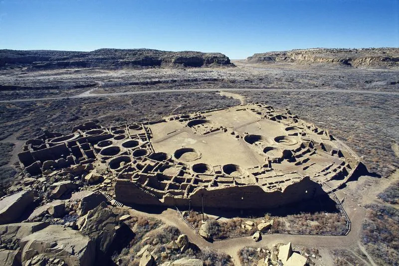
The canyon runs roughly north-west to south-east through sandstone mesas in the centre of the San Juan Basin. The park covers about 137 square kilometres and holds the core great houses (Pueblo Bonito, Chetro Ketl, Pueblo del Arroyo, Pueblo Alto, Peñasco Blanco, Una Vida and others), hundreds of smaller house sites, and Fajada Butte at the canyon's south-east end[2]. Pueblo Bonito covers about 3 acres, with a plan divided by a north-south wall, a great kiva on each side and more than thirty smaller kivas[3].
Six road systems leave the canyon and connect it with about thirty outliers. They are wide, straight, engineered surfaces with beds about 9 metres across; the Great North Road runs straight from Pueblo Alto about 56 km north[2]. They were traditionally mapped from aerial photographs and ground survey, and many that were plain in the 1980s are now nearly invisible on the ground, which is why lidar matters[13].
The park has been federal land since 1907, a national historical park since 1980 and a World Heritage Site since 1987[1]. In June 2023 the Interior Department withdrew federal minerals within 10 miles of the park from leasing for 20 years; in July 2026 a draft environmental assessment proposed revoking that withdrawal, and as of late August 2026 the Department was reviewing comments[14]. This is context for the landscape, not part of the archaeological question.
Timeline
What was found
Pueblo Bonito was dug first and most. The Hyde Exploring Expedition under Richard Wetherill and George Pepper of the American Museum of Natural History excavated 190 rooms from 1896 to 1900, and Neil Judd of the Smithsonian excavated several hundred more from 1921 to 1927[3][1]. Pepper's crew emptied Room 28, which held 174 whole vessels, 112 of them tall cylinder jars; fewer than 200 cylinder jars are known from the whole Southwest, and almost all are now in New York[15][16]. Room 33, a burial crypt in the oldest part of the building, held a man who died violently and thirteen others buried after him over about 330 years[3][17].
The canyon's imports are the best measured of any Puebloan site. Scarlet macaws, a tropical bird from Mesoamerica, were brought to Pueblo Bonito from about 900 to 975 onward and until about 1150, most of them before the eleventh-century building peak[18]. Residues on cylinder-jar sherds carry theobromine, the biomarker for cacao, the earliest evidence of chocolate drinking north of Mexico, dated about 1000 to 1125[19]. Construction timbers came from the Chuska, Zuni and Mount Taylor ranges[5][6]; the large pine stump in Pueblo Bonito's plaza has been traced by both tree rings and strontium to the Chuskas[20].
Lidar has extended the road record. Friedman, Sofaer and Weiner showed in 2017 that it recovers known and new segments of the Great North Road and the roads around Pueblo Alto[13]. The San Juan Valley Archaeological Project published a field survey and ceramic analysis of the Great North Road in 2024[21]. In 2025 Weiner, Friedman and Stein used free 1 m USGS elevation models to show that the Gasco Road, about 80 km south of the canyon, runs for more than 6 km with a second road parallel to it, both aligned on springs and on the winter solstice sunrise over Mount Taylor[22][23]. On Fajada Butte, three sandstone slabs against the cliff cast light onto two spiral petroglyphs; Anna Sofaer recorded the light pattern in 1977 and published it in 1979 as a marker of the solstices and equinoxes[11].
What is known
The building sequence is fixed by tree rings: the earliest great-house rooms at Pueblo Bonito in the mid-800s, the main expansions at 1047 to 1049 and 1077 to 1082, and the last construction in the early 1100s, with many episodes falling in wet decades when food could be stored[4]. Dated wood from the canyon and from Aztec Ruins is compiled in the Chaco Research Archive's tree-ring database, which the Laboratory of Tree-Ring Research has expanded from its specimen cards[24].
The timber was imported. Spruce and fir beams carry strontium ratios that match the Chuska and San Mateo (Mount Taylor) mountains and not the equally close San Pedro Mountains; logs from both sources appear in the same room and year by 974, which points to stockpiling and cooperation[5]. Ring-width matching of 170 timbers put 70 percent in the Chuska and Zuni mountains, with the Zunis supplying nearly all before 1020 and the Chuskas dominant by 1060[6]. Isotopes have also sourced ponderosa pine, the commonest beam[25].
Inequality appears early. New radiocarbon dates on Room 33 put marked social differentiation 150 to 200 years earlier than once thought[17], and the macaws were arriving by the tenth century[18]. In 2017 Kennett and colleagues reported that nine of the Room 33 burials share one mitochondrial genome and that nuclear DNA shows mother-daughter and grandmother-grandson links, which they read as an elite matriline lasting about 330 years[8]. Indigenous scientists objected that no tribes had been consulted, that the paper described ancestors insensitively, and that NAGPRA leaves research on such remains unregulated[26]. In 2025 a study initiated and controlled by Picuris Pueblo found genetic continuity between Picuris people, ancient and living, and the Pueblo Bonito burials[27].
The local environment was poor and grew poorer. Pollen and plant remains show the canyon's pinyon-juniper woodland cut back from the last centuries BC and largely gone by the Bonito phase[7]. Benson and Grimstead calculated that the canyon floor could grow maize for about 1,000 people at most and that small game could not supply the protein for a population of 2,300, so either food was imported or few lived there year-round[10][28][29]. Great-house building ended in the early 1100s, and the system came apart from about 1140, during a drought that began about 1130[4][2].
The explanations
What Chaco was. A ceremonial or pilgrimage centre: great houses with few permanent residents, filled at gatherings and supplied from outside; it predicts small resident households, large stores and episodic deposits of food and goods brought in[7][30]. A hereditary elite: the Room 33 matriline, the early macaws and the cacao point to a ruling house; this predicts continuity of privileged burial and control of imports across generations[8][17]. A lived-in town: Lentz and colleagues argue the canyon was farmed and lived in for a millennium[7]. A regional polity: Kohler, Brumbaugh and Bocinsky argue that the regional system held more people than any earlier estimate and that its rapid expansion after 1040 fits models of colonial systems, with roads and shrines as a polity's infrastructure[9]. These are not exclusive; they differ on the size of the resident population and on who controlled the imports.
How many lived there. Estimates for the canyon have fallen since the 1970s; the NPS notes that research then sharply reduced earlier figures for the great houses[1]. Benson's carrying-capacity work puts the self-supporting population under 1,000[10]. At the regional scale the 2025 estimate goes the other way[9]. The two can both be right if the canyon was a small, provisioned centre of a populous region.
What the roads were for. They moved timber and probably food: the beams came from 75 to 100 km away, and Benson's import calculation implies many thousands of foot trips[5][28]. But the roads are wider and straighter than foot traffic needed, some run in parallel pairs, and modern Pueblo people associate the Great North Road with their ancestors' arrival from the north[2][22]. Sofaer and others read the roads as cosmographic, laid out to directions and sky events, and the Gasco roads' solstice alignment is the strongest recent case[31][22]. Kohler's reading treats them as the visible network of a polity[9].
Whether the buildings encode astronomy. On Fajada Butte three slabs cast midday light on two spirals: one dagger of light crosses the centre of the large spiral at the summer solstice, two bracket it at the winter solstice, and one bisects the small spiral at the equinoxes[11]. Whether people set the slabs is disputed; Newman, Mark and Vivian judged them a natural rockfall that the carvers put to use[32]. Zeilik, and later Schaefer and Stamm, read the site as a sun shrine for the solstices rather than a calendar, and the lunar standstill markings Sofaer's team reported in 1982 as chance[12][33][34]. In 1989 the middle slab was found to have pivoted, and the markings no longer form as they were recorded; the photographs of 1978 to 1987 and a model built from 1984 photogrammetry and a 2005 laser scan are the record[35][36]. For the buildings, the Solstice Project's survey put Pueblo Bonito's main walls within a quarter of a degree of the cardinal directions and twelve of fourteen major buildings within a few degrees of solar or lunar azimuths, and found lines between buildings on the same bearings[37]. Malville and Munro argue that most orientations follow an older tradition of south-facing house plans, and that the alignments between buildings to the lunar standstills are products of the topography[38]. McCluskey's point that the noon shadow events at Fajada's other sites are about what chance gives is the general objection to alignment counts made without a null model[39].
Why building stopped and people left. Drought: a drought of about fifty years began about 1130, as building ended, and Benson and colleagues have tested the twelfth-century migrations against tree-ring drought records[2][40]. Degradation: centuries of woodcutting and erosion left the canyon unable to absorb a drought[7]. Movement rather than collapse: descendant communities describe a migration, not an end, and the Picuris genomes show continuity with Pueblo Bonito[1][27].
Published claims
| Year | Who | Claimed | Status | Reason |
|---|---|---|---|---|
| 1979 | Anna Sofaer, Volker Zinser and Rolf Sinclair[11] | Three slabs on Fajada Butte were set or shaped so that midday light marks the solstices and equinoxes on two spirals, making a solar calendar. | Disputed | The light markings are accepted, but others read the slabs as a natural rockfall and the site as a sun shrine rather than a calendar[32][34]. |
| 1982 | Evelyn Newman, Robert Mark and R. Gwinn Vivian[32] | The Fajada slabs are a natural rockfall, and the spirals were carved where its light happened to fall. | Still possible | No study has settled whether the slabs were placed or shaped, and the record of their geometry now rests on photographs and a model made before the middle slab shifted[36]. |
| 1982 | Anna Sofaer, Rolf Sinclair and LeRoy Doggett[33] | At moonrise the eastern slab's shadow marks the moon's minor and major standstills on the large spiral, so the site tracked the 18.6-year lunar cycle. | Disputed | Zeilik and later Schaefer and Stamm judged the lunar shadow positions to be chance by-products of the slabs[12][34]. |
| 1985 | Michael Zeilik[12] | Fajada Butte was a sun shrine for watching the solstices, not a precise calendar, and the lunar markings are unsupported. | Most likely | Schaefer and Stamm's 2020 review reached the same reading, though Sofaer's team rejected Zeilik's assessment[34][43]. |
| 1989 | Anna Sofaer, Michael Marshall and Rolf Sinclair[44] | The Great North Road runs almost due north for tens of kilometres with few settlements on it because it expressed a cosmology, not a need to travel. | Still possible | The roads also had a transport role, and the clearest support since is one road pair at Gasco aligned to the winter solstice[28][22]. |
| 1996 | Thomas Windes and Dabney Ford[4] | Tree rings from 4,294 pieces of wood date Pueblo Bonito's main building episodes to the mid-800s, 1047 to 1049 and 1077 to 1082. | Accepted | The dates are compiled with the rest of the canyon's tree-ring record and have not been seriously challenged[24]. |
| 1999 | Stephen Lekson[46] | Chaco, Aztec Ruins and Paquimé were laid out on one north-south meridian as successive capitals of the same ruling tradition. | Disputed | Southwestern archaeologists object that the material culture of the three centres is too different, though many accept the move from Chaco to Aztec[45]. |
| 2001 | Colin Renfrew[47] | Chaco was an essentially egalitarian centre of pilgrimage, where goods were made and used for periodic gatherings at the great houses. | Still possible | Low estimates of the resident population fit it, but early burials and imports point to a hereditary elite rather than an egalitarian centre[10][17]. |
| 2001 | Nathan English and colleagues[5] | Strontium isotopes show the great-house spruce and fir came from the Chuska and Mount Taylor ranges, more than 75 km away. | Accepted | Ring-width matching of 170 timbers independently placed most beams in distant ranges[6]. |
| 2007 | Larry Benson and colleagues[40] | The mid-twelfth-century departure from Chaco followed a severe drought shown in tree-ring records. | Most likely | The drought's timing matches the end of building, but woodland loss and a long tradition of migration are argued as causes too[7][1]. |
| 2007 | Anna Sofaer[37] | Twelve of fourteen major Chacoan buildings are oriented to the cardinal directions, the solstices or the lunar standstills, and placed on such bearings to one another. | Disputed | Malville and Munro trace most orientations to older south-facing house plans and the inter-building lines to the canyon's topography[38]. |
| 2009 | Patricia Crown and W. Jeffrey Hurst[19] | Residues on Pueblo Bonito sherds, probably from cylinder jars, carry theobromine, showing cacao was drunk there about 1000 to 1125. | Accepted | The result has not been seriously challenged and the park presents it as established[16]. |
| 2010 | Stephen Plog and Carrie Heitman[17] | New radiocarbon dates on the Room 33 crypt put marked social inequality at Chaco 150 to 200 years earlier than thought. | Most likely | Early macaw imports and the Room 33 genomes support early differentiation[18][8]. |
| 2014 | J. McKim Malville and Andrew Munro[38] | Most great houses face south to south-south-east by an older building tradition, and the claimed lunar alignments between them are products of topography. | Most likely | No study has answered the critique with a test of the alignments against chance, so the building-tradition reading stands as the simpler one[37]. |
| 2016 | Christopher Guiterman and colleagues[6] | Ring-width matching places most dated timbers in the Zuni and Chuska mountains, with the Zunis supplying nearly all before 1020 and the Chuskas dominant by 1060. | Accepted | It agrees with the strontium sourcing and with the later Chuska origin of Pueblo Bonito's plaza tree[5][20]. |
| 2017 | Douglas Kennett and colleagues[8] | Nine Room 33 burials share one mitochondrial genome, the remains of an elite matriline that lasted about 330 years. | Most likely | The genetic result has not been challenged; the objections were to the lack of tribal consultation and the description of ancestors[26]. |
| 2019 | Larry Benson and Deanna Grimstead[10] | The canyon could grow maize and hunt game for no more than about 1,000 people, so either food was imported or few lived there year-round. | Most likely | It fits the long decline in canyon estimates, while Kohler's larger figure applies to the whole regional system[1][9]. |
| 2020 | Bradley Schaefer and James Stamm[34] | At Fajada Butte at most two of the four claimed markings are intentional, the lunar ones are chance, and the site was a sun shrine. | Most likely | It agrees with Zeilik's reading, and the site can no longer be re-observed because the middle slab shifted in 1989[12][35]. |
| 2021 | David Lentz and colleagues[7] | Centuries of woodcutting stripped the canyon's pinyon-juniper woodland and left the landscape unable to absorb drought. | Still possible | The pollen record of woodland loss is not disputed, but its weight against the drought as a cause has not been tested[40]. |
| 2025 | Robert Weiner and colleagues[22] | Lidar shows the Gasco Road and a parallel road aligned with springs and the winter solstice sunrise over Mount Taylor. | Still possible | It is one road pair, and alignment counts at Chaco have been faulted for lacking a test against chance[38]. |
| 2025 | Thomaz Pinotti and colleagues, with Picuris Pueblo[27] | Ancient and living Picuris people are genetically continuous with the Pueblo Bonito burials. | Accepted | The genomes agree with Picuris oral history and with the park's account of descendant communities[1]. |
| 2025 | Timothy Kohler, Laura Brumbaugh and Kyle Bocinsky[9] | The Chaco regional system held more people than even the highest earlier estimates, and grew after 1040 like a colonial system. | Still possible | It is a model-based estimate not yet tested against settlement counts, and canyon-scale estimates point the other way[10]. |
What would settle it
The population question can be tested with the data that exist: a room-by-room count of hearths, storage and residential features for every dated great-house room in the tree-ring database, set against the food budget, would bound the resident population[24][10]. Isotope sourcing of the maize and fauna, as has been done for timber, would show how much food was imported and from where[28][5].
The roads need a complete lidar map of the basin from public elevation data, with each segment's width, orientation and endpoints recorded, and a test of the alignment claims against random orientations under the same terrain[41][22]. The astronomical readings need the same null-model test for great-house walls and shrine lines, decided before the data are examined, starting from the Solstice Project's published wall azimuths[42][37][12]. Any further genetic work on the ancestors buried at Chaco should follow the Picuris model of tribal initiation and control[27][26].
Questions
1 of 9 questions are answered.
Evidence 62 findings
Artifacts
The films, photos, papers and objects this mystery rests on, each with its own key and its distance from the original.
See also
References
- 1.National Park Service, C. n.d.. Chaco Brief History. nps.gov.cited 13 times hereSRC0D9KT25Y7TW6
- 2.Wikipedia contributors n.d.. Chaco Culture National Historical Park. Wikipedia.cited 7 times hereSRC0D9KT2DR405C
- 3.Wikipedia contributors n.d.. Pueblo Bonito. Wikipedia.cited 5 times hereSRC0D9KT2NJ5FBV
- 4.Windes, T., Ford, D. 1996. The Chaco Wood Project: The Chronometric Reappraisal of Pueblo Bonito. American Antiquity 61(2): 295-310.doicited 9 times hereSRC0D9KT2XC3XB7
- 5.English, N., Betancourt, J., Dean, J. et al. 2001. Strontium isotopes reveal distant sources of architectural timber in Chaco Canyon, New Mexico. Proceedings of the National Academy of Sciences 98(21): 11891-11896.doicited 10 times hereSRC0D9KT3D01V6X
- 6.Guiterman, C., Swetnam, T., Dean, J. 2016. Eleventh-century shift in timber procurement areas for the great houses of Chaco Canyon. Proceedings of the National Academy of Sciences 113(5): 1186-1190.doicited 8 times hereSRC0D9KT3WM6189
- 7.Lentz, D., Slotten, V., Dunning, N. et al. 2021. Ecosystem impacts by the Ancestral Puebloans of Chaco Canyon, New Mexico, USA. PLOS ONE 16(10): e0258369.doicited 8 times hereSRC0D9KT9R418H9
- 8.Kennett, D., Plog, S., George, R. et al. 2017. Archaeogenomic evidence reveals prehistoric matrilineal dynasty. Nature Communications 8: 14115.doicited 6 times hereSRC0D9KT4C82JBK
- 9.Kohler, T., Brumbaugh, L., Bocinsky, R. 2025. How Many People Lived in the Chaco Regional System, and Why It Matters. KIVA 91(4): 361-391.doicited 11 times hereSRC0D9KT9GA76P7
- 10.Benson, L., Grimstead, D. 2019. Prehistoric Chaco Canyon, New Mexico: Residential population implications of limited agricultural and mammal productivity. Journal of Archaeological Science 108: 104971.doicited 8 times hereSRC0D9KT8H215DB
- 11.Sofaer, A., Zinser, V., Sinclair, R. 1979. A Unique Solar Marking Construct. Science 206(4416): 283-291.doicited 10 times hereSRC0D9KT6AR0XPY
- 12.Zeilik, M. 1985. The Fajada Butte Solar Marker: A Reevaluation. Science 228(4705): 1311-1313.doicited 13 times hereSRC0D9KT6JJ6MNC
- 13.Friedman, R., Sofaer, A., Weiner, R. 2017. Remote Sensing of Chaco Roads Revisited. Advances in Archaeological Practice 5(4): 365-381.doicited 2 times hereSRC0D9KT7HT2A4W
- 14.Leger Fernández, T., Huffman, J., and 16 other Members of the US House of Representatives 2026. Letter to Secretary of the Interior Doug Burgum re Chaco Canyon (proposed revocation of Public Land Order 7923). US House of Representatives, 20 August 2026.cited 4 times hereSRC0D9KTA7R32Z4
- 15.Historic Santa Fe Foundation 2021. The House of the Cylinder Jars (book review and lecture notice). historicsantafe.org, 11 January 2021.cited 2 times hereSRC0D9KT5KA0Q68
- 16.National Park Service, C. n.d.. Pre-Columbian Chocolate Discovered at Chaco. nps.gov.cited 3 times hereSRC0D9KT5BG265G
- 17.Plog, S., Heitman, C. 2010. Hierarchy and social inequality in the American Southwest, A.D. 800-1200. Proceedings of the National Academy of Sciences 107(46): 19619-19626.doicited 4 times hereSRC0D9KT62Y27B3
- 18.Watson, A., Plog, S., Culleton, B. et al. 2015. Early procurement of scarlet macaws and the emergence of social complexity in Chaco Canyon, NM. Proceedings of the National Academy of Sciences 112(27): 8238-8243.doicited 6 times hereSRC0D9KT5V47827
- 19.Crown, P., Hurst, W. 2009. Evidence of cacao use in the Prehispanic American Southwest. Proceedings of the National Academy of Sciences 106(7): 2110-2113.doicited 5 times hereSRC0D9KT53P03ZH
- 20.Guiterman, C., Baisan, C., English, N. et al. 2020. Convergence of Evidence Supports a Chuska Mountains Origin for the Plaza Tree of Pueblo Bonito, Chaco Canyon. American Antiquity 85(2): 331-346.doicited 2 times hereSRC0D9KT44E5J68
- 21.Franklin, H., Morenon, E. 2024. The Chaco Great North Road: Archaeological Survey and Ceramic Analysis by the San Juan Valley Archaeological Project. KIVA 90(2): 170-184.doicited 1 time hereSRC0D9KT8986NCN
- 22.Weiner, R., Friedman, R., Stein, J. 2025. Parallel roads, solstice and sacred geography at the Gasco Site: a Chacoan ritual landscape. Antiquity 99(404): 500-516.doicited 5 times hereSRC0D9KT7SM2XXE
- 23.Archaeology magazine 2025. Lidar Reveals Sacred Roads Near Chaco Canyon. Archaeology (Archaeological Institute of America), 26 February 2025.cited 1 time hereSRC0D9KT81E2963
- 24.Chaco Research Archive, Laboratory of Tree-Ring Research, U. n.d.. Tree-Ring Databases (CRA Tree-Ring Database and 2015 LTRR great house specimen database). Chaco Research Archive.cited 6 times hereSRC0D9KT3561VV0
- 25.Reynolds, A., Betancourt, J., Quade, J. et al. 2005. 87Sr/86Sr sourcing of ponderosa pine used in Anasazi great house construction at Chaco Canyon, New Mexico. Journal of Archaeological Science 32: 1061-1075.doicited 2 times hereSRC0D9KT3MT0A5W
- 26.Claw, K., Lippert, D., Bardill, J. et al. 2017. Chaco Canyon dig unearths ethical concerns. Human Biology 89(3): 177-180.doicited 1 time hereSRC0D9KT4M25FA8
- 27.Pinotti, T., Adler, M., Mermejo, R. et al. 2025. Picuris Pueblo oral history and genomics reveal continuity in US Southwest. Nature 642: 125-132.doicited 5 times hereSRC0D9KT4VW722A
- 28.Benson, L., Grimstead, D., Stein, J. et al. 2019. Prehistoric Chaco Canyon, New Mexico: Importation of meat and maize. Journal of Archaeological Science 111: 105015.doicited 3 times hereSRC0D9KT8RW320A
- 29.University of Colorado Boulder, C. 2019. Food may have been scarce in Chaco Canyon. CU Boulder Today, 10 July 2019.cited 3 times hereSRC0D9KT90P7RX6
- 30.Harmon, D. 2020. New research posits much smaller population at what is now Chaco Culture NHP. George Wright Society (Parks Stewardship Forum news), 14 January 2020.cited 2 times hereSRC0D9KT98G0NBA
- 31.The Solstice Project n.d.. The Solstice Project. solsticeproject.org.cited 4 times hereSRC0D9KT7262QVM
- 32.Newman, E., Mark, R., Vivian, R. 1982. Anasazi Solar Marker: The Use of a Natural Rockfall. Science 217(4564): 1036-1038.doicited 6 times hereSRC0D9KTBPM2X1Q
- 33.Sofaer, A., Sinclair, R., Doggett, L. 1982. Lunar Markings on Fajada Butte, Chaco Canyon, New Mexico. Archaeoastronomy in the New World, ed. Anthony F. Aveni, Cambridge University Press: 169-186.cited 5 times hereSRC0D9KTB7030KR
- 34.Schaefer, B., Stamm, J. 2020. A Case Study of the Picture Rocks Sun Dagger, Plus a Review of the Intentionality of Sun Daggers. Journal of Astronomical History and Heritage 23(3): 427-451.doicited 9 times hereSRC0D9KTCE25TNP
- 35.Palca, J. 1989. Sun Dagger Misses Its Mark. Science 244(4912): 1538.doicited 2 times hereSRC0D9KTBYE1S3J
- 36.Sofaer, A., Price, A., Holmlund, J. et al. 2011. The Sun Dagger Interactive Computer Graphics Model: A Digital Restoration of a Chacoan Calendrical Site. Contemporary Archaeologies of the Southwest, University Press of Colorado: 67-92.doicited 9 times hereSRC0D9KTBET0V0D
- 37.Sofaer, A. 2007. The Primary Architecture of the Chacoan Culture: A Cosmological Expression. The Architecture of Chaco Canyon, New Mexico, ed. Stephen H. Lekson, University of Utah Press: 225-254.cited 7 times hereSRC0D9KTAZ60AS8
- 38.Malville, J., Munro, A. 2014. Great Houses and the Sun: Astronomy of Chaco Canyon. Handbook of Archaeoastronomy and Ethnoastronomy, ed. Clive L. N. Ruggles, Springer: 577-591.doicited 7 times hereSRC0D9KTC680BZM
- 39.Wikipedia contributors n.d.. Fajada Butte. Wikipedia.cited 4 times hereSRC0D9KT7A00RN4
- 40.Benson, L., Petersen, K., Stein, J. 2007. Anasazi (Pre-Columbian Native-American) Migrations During the Middle-12th and Late-13th Centuries: Were they Drought Induced?. Climatic Change 83: 187-213.doicited 2 times hereSRC0D9KT9ZY76N5
- 41.US Geological Survey n.d.. The National Map Downloader (3D Elevation Program lidar and DEMs). The National Map.cited 2 times hereSRC0D9KTAFJ0431
- 42.Sofaer, A., Weiner, R., Stone, W. 2017. Inter-site Alignments of Prehistoric Shrines in Chaco Canyon to the Major Lunar Standstill. The Science of Time 2016 (Astrophysics and Space Science Proceedings 50), Springer: 79-101.doicited 3 times hereSRC0D9KT6TC4WTP
- 43.Sofaer, A., Sinclair, R. 1986. An Appraisal of Michael Zeilik's 'A Reassessment of the Fajada Butte Solar Marker'. Journal for the History of Astronomy 17 (Archaeoastronomy supplement 10): S59-S69.doicited 2 times hereSRC0D9KTAQC0PDW
- 44.Sofaer, A., Marshall, M., Sinclair, R. 1989. The Great North Road: A Cosmographic Expression of the Chaco Culture of New Mexico. World Archaeoastronomy, ed. Anthony F. Aveni, Cambridge University Press: 365-376.cited 1 time hereSRC0D9KTCNW3YNQ
- 45.Wikipedia contributors n.d.. Chaco Meridian. Wikipedia.cited 1 time hereSRC0D9KTEMC0HWX
- 46.Lekson, S. 1999. The Chaco Meridian: Centers of Political Power in the Ancient Southwest. AltaMira Press.cited 1 time hereSRC0D9KTECJ0Z84
- 47.Renfrew, C. 2001. Production and Consumption in a Sacred Economy: The Material Correlates of High Devotional Expression at Chaco Canyon. American Antiquity.doicited 1 time hereSRC0D9KTEW62CCM