The Bermuda Triangle
The Bermuda Triangle is a story about statistics told through anecdotes. Its claim is that an unusual number of ships, aircraft and people have vanished, without distress calls or wreckage, in the waters between Florida, Bermuda and Puerto Rico. The area has no official boundary or name, and writers draw it to suit[1]. The idea was assembled in the 1960s by Vincent Gaddis and made famous by Charles Berlitz's 1974 bestseller, which presented a list of losses as unexplained and canvassed anomalous causes[2][3].
In 1975 Lawrence David Kusche, a reference librarian at Arizona State University, went back to the contemporary records for every case: newspapers, Lloyd's casualty reports, official inquiries and weather data. He found that almost all the incidents had ordinary explanations once researched; that the few left open were those about which nothing could be found; that some vessels were never known to have been in the area when lost; and that many incidents were not considered mysterious until writers retold them years later. He called it "a manufactured mystery"[4][5].
The US government agrees. NOAA says there is no evidence that disappearances occur more often in the Triangle than in any other large, well-travelled area of ocean, and points to hurricanes, the Gulf Stream and shallow island waters as hazards that explain many losses[1]. The Coast Guard does not recognise the area as a place of specific hazard[6]. Marine insurers' casualty data, compiled by Lloyd's List Intelligence, rank other seas far above it[7][8]. The case is settled. It is kept here as a statistics exemplar, because the one analysis that would close it numerically, losses divided by traffic for the Triangle and for comparable seas, has never been published and can now be built from open data. Of the 4 questions on this site, 3 are answered.
Key questionsset by the editors
What is known
Ships and aircraft have been lost in the area, as in every busy sea. The western North Atlantic carries heavy traffic to and from US East Coast and Gulf ports, the Bahamas and the Caribbean, and private boating and flying from Florida. Most Atlantic hurricanes cross it; the Gulf Stream can raise sudden, violent seas; and the many islands make for shallow, hazardous water[1].
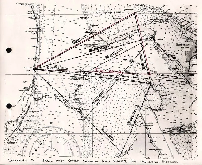
The best-documented loss is Flight 19. On 5 December 1945 five Navy TBM Avengers with 14 men left Naval Air Station Fort Lauderdale at 2:10 pm on a training flight, Navigation Problem No. 1, which ran east to bomb a target near Bimini, north over Grand Bahama and back[9]. At about 3:40 pm the flight leader, Lt Charles C. Taylor, radioed that both his compasses were out and that he believed he was over the Florida Keys; he was in fact north-east of Fort Lauderdale. The flight changed course repeatedly as the pilots disagreed about where they were. The last transmission, at 7:04 pm, said they would ditch together when the first aircraft fell below ten gallons of fuel; the sea was rough and night had fallen[9]. A PBM-5 Mariner flying boat with 13 men, sent from Banana River to search, was lost the same evening; the tanker SS Gaines Mills reported a burst of flames at 7:50 pm and the escort carrier USS Solomons lost the aircraft on radar at the same position[10].
Timeline
The search
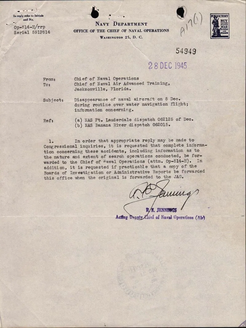
For the individual cases the search has been in archives. Kusche's method was to set each story in the popular books against what was recorded at the time; the solution, he said, came from interlibrary loan, not from an expedition[4]. For Flight 19 the Navy's own investigation records survive at the National Archives at Fort Worth, including the map of the navigation problem and the correspondence[9]. The Navy board concluded that the flight leader had lost his position; after his mother's appeal the Board for Correction of Naval Records amended the finding to cause unknown[10]. The amendment changed the attribution of blame, not the account of what happened: no wreckage of either aircraft has been recovered[9].
For the pattern as a whole the search is statistical. NOAA's conclusion rests on comparison with other busy seas[1]. Insurers' casualty data give the best modern counts: of 905 total losses of vessels over 100 gross tons worldwide from 2016 to 2025, 21 were in the West Indies region, against 255 in the waters from the South China Sea to the Philippines and 120 in the East Mediterranean and Black Sea[7]. A 2013 WWF study of shipping casualties since 1999, also built on Lloyd's List Intelligence data, found the same hotspots and did not place the Caribbean or the Triangle among them[8][11]. Neither study divides losses by traffic, and the insurers' West Indies region is not the Triangle, so they show that the area is unremarkable in raw counts, not that its rate per voyage is ordinary.
The explanations
The ordinary explanation is that the losses are what weather, currents, traffic and human error produce in any busy sea, and that the pattern is an artefact of selective retelling. Kusche's findings support both halves: incidents with ordinary causes, and a list padded with cases that happened elsewhere, at other times, or not as told[4][5]. NOAA and the Coast Guard take the same view[1][6].
Two physical mechanisms have been proposed to explain losses without trace. Methane erupting from seabed sediments could in principle reduce buoyancy: laboratory and simulation work shows that a single large bubble can sink a floating body of similar size, though the study was motivated by the North Sea and does not estimate how often such events occur anywhere[12]. NOAA lists methane among the more grounded ideas "if not in evidence"[1]. Compass behaviour is the second: NOAA notes evidence that in parts of the area a magnetic compass can point to true rather than magnetic north, a navigational hazard rather than an anomaly[1].
The anomalous explanations (lost Atlantis, vortices, extraterrestrials, electromagnetic forces) are the ones Berlitz canvassed[3]. They rest on the premise of an excess of unexplained losses, which the case-level research removed[4].
Published claims
| Year | Who | Claimed | Status | Reason |
|---|---|---|---|---|
| 1965 | Vincent H. Gaddis[2] | Ships and aircraft vanish in a 'Bermuda Triangle' between Miami, Bermuda and San Juan in a pattern that ordinary causes do not explain. | Ruled out | Traced to contemporary records, the cases on such lists were ordinary, misreported or happened elsewhere[4], and NOAA finds no excess of losses[1]. |
| 1974 | Charles Berlitz[3] | Well-documented losses in the Triangle, Flight 19 among them, cannot be explained by ordinary causes and may involve forces such as Atlantean technology or extraterrestrials. | Ruled out | Kusche found the mysterious details in Berlitz's cases came from later retellings[4], and Flight 19's own records show a navigation failure[9]. |
| 1975 | Lawrence David Kusche[5] | The Triangle is a manufactured mystery: each case, checked against contemporary records, has an ordinary cause or was misreported. | Accepted | No later case study has overturned his findings, and NOAA and the Coast Guard take the same view[1][6]. |
| 1975 | Lawrence David Kusche[4] | The few incidents that remain unsolved are those for which no information can be found, not ones that defy explanation. | Accepted | The unsolved residue in Kusche's survey is cases without a surviving record[4]; nothing since has shown otherwise[1]. |
| 2003 | D. A. May and J. J. Monaghan[12] | A single large gas bubble rising under a ship can remove enough buoyancy to sink it. | Still possible | The mechanism works in the laboratory, but no eruption of the required size has been observed in the area[1][17]. |
| 2010 | NOAA National Ocean Service[1] | There is no evidence that disappearances occur more often in the Triangle than in any other large, well-travelled area of ocean. | Accepted | The Coast Guard takes the same view and insurers' loss counts agree[6][7], though no one has published a loss rate adjusted for traffic. |
| 2013 | WWF[8] | The world's shipping-casualty hotspots since 1999 are the South China Sea and East Indies, the east Mediterranean and Black Sea, and the North Sea; the Caribbean is not among them. | Accepted | Built from Lloyd's List Intelligence data and reported by two outlets[8][11]; Allianz's 2016 to 2025 counts show the same pattern[7]. |
| 2014 | Science in Siberia (Russian Academy of Sciences)[17] | Methane hydrate blowouts on the seabed, like those thought to have made the Siberian craters, could explain ships and aircraft lost in the Triangle. | Disputed | Specialists reply that no such release has occurred there since the end of the last ice age[17], though the sinking mechanism itself is sound in the laboratory[12]. |
| 2017 | Michael Wright and Joseph Ryan (US National Archives)[9] | The official record shows Flight 19 was lost because its leader misjudged his position, and the flight ran out of fuel and ditched at night in rough seas. | Accepted | The radio logs and Navy file support each step[9][18]; only the wreckage is missing. |
| 2018 | Simon Boxall (University of Southampton)[19] | Rogue waves, built where storms from several directions meet, could sink large ships such as USS Cyclops in minutes. | Still possible | Shown with a model in a wave tank for a television documentary[19]; no published study ties any loss in the area to a rogue wave. |
| 2021 | Samuel J. Cox (Naval History and Heritage Command)[10] | Training 49, the flying boat sent to search for Flight 19, was most probably destroyed by an in-flight fire or explosion. | Most likely | A tanker saw flames and a ship lost the aircraft on radar at the same position, but the Navy board reached no firm conclusion[10]. |
| 2026 | Allianz Commercial[7] | The West Indies accounted for 21 of 905 total losses of large vessels worldwide in 2016 to 2025. | Accepted | An insurer's count of reported total losses[7]; it agrees with the WWF ranking[8]. |
What would settle it
It is settled at the level of cases and official assessment. A quantitative close would be a published loss rate per unit of traffic for a fixed Triangle polygon and for comparison seas of similar traffic and weather, with confidence intervals. The pieces exist in open data: charted wrecks from NOAA's electronic charts, civil aviation accidents from the NTSB database, vessel traffic from AIS, and hurricane tracks from IBTrACS[13][14][15][16]. Lloyd's List Intelligence casualty data, through an insurer or WWF, would allow the same comparison for merchant ships worldwide[7].
Questions
3 of 4 questions are answered.
Evidence 26 findings
Artifacts
The films, photos, papers and objects this mystery rests on, each with its own key and its distance from the original.
See also
References
- 1.NOAA National Ocean Service 2010. What is the Bermuda Triangle?. NOAA Ocean Facts (oceanservice.noaa.gov).cited 16 times hereSRC0D666QAA5X0S
- 2.Gaddis, V. 1965. Invisible Horizons: True Mysteries of the Sea. Chilton Books, Philadelphia.cited 3 times hereSRC0D666R9J79XR
- 3.Berlitz, C. 1974. The Bermuda Triangle. Doubleday, Garden City, New York.cited 7 times hereSRC0D666RHC4P9R
- 4.Kusche, L. 1975. The Bermuda Triangle: A Librarian's Pursuit of Excellence. North Carolina Libraries 33(4).doicited 9 times hereSRC0D666QSY6T29
- 5.Kusche, L. 1975. The Bermuda Triangle Mystery—Solved. Harper & Row, New York.cited 4 times hereSRC0D666R1R02GB
- 6.Navy Department Library, N. n.d.. Bermuda Triangle: A Selective Bibliography. Naval History and Heritage Command (history.navy.mil).cited 2 times hereSRC0D666QJ438YX
- 7.Allianz Commercial 2026. Safety and Shipping Review 2026. Allianz Commercial, June 2026 (data from Lloyd's List Intelligence Casualty Statistics).cited 5 times hereSRC0D666SGM05HX
- 8.Barber, E. 2013. Bermuda Triangle doesn't make the cut on list of world's most dangerous oceans. The Christian Science Monitor, 10 June 2013.cited 3 times hereSRC0D666SRE73QR
- 9.Wright, M., Ryan, J. 2017. "Uncertain as to in what position lay the Peninsula of Florida": The Official Record and the Loss of Flight 19. Pieces of History, US National Archives blog, 16 October 2017.cited 15 times hereSRC0D666RS65P8P
- 10.Cox, S. 2021. H-057-4: The Disappearance of "Flight 19" and "Training 49", 5 December 1945. Naval History and Heritage Command, H-Gram 057.cited 7 times hereSRC0D666S1005GX
- 11.The Maritime Executive 2013. Accidents at Sea: WWF Report Looks at 15 Years of Shipping Incidents. The Maritime Executive, 10 June 2013.cited 1 time hereSRC0D666T08732X
- 12.May, D., Monaghan, J. 2003. Can a single bubble sink a ship?. American Journal of Physics 71(9): 842–849.doicited 5 times hereSRC0D666S8T2ZN3
- 13.NOAA Office of Coast Survey n.d.. Wrecks and Obstructions Database (AWOIS retired; ENC Direct to GIS). NOAA Office of Coast Survey (nauticalcharts.noaa.gov).cited 2 times hereSRC0D666T8247PY
- 14.US National Transportation Safety Board n.d.. NTSB Downloadable Aviation Datasets (avall.zip, Pre2008.zip, PRE1982.zip). NTSB CAROL (data.ntsb.gov).cited 2 times hereSRC0D666TFW08FB
- 15.BOEM and NOAA Office for Coastal Management, M. n.d.. Vessel Traffic (AIS) data. MarineCadastre.gov.cited 2 times hereSRC0D666TQP5P5A
- 16.Knapp, K., Kruk, M., Levinson, D. et al. 2010. The International Best Track Archive for Climate Stewardship (IBTrACS). Bulletin of the American Meteorological Society 91(3): 363–376.doicited 2 times hereSRC0D666TZG66AF
- 17.Lewis, T. 2014. Could Gas Explosions Explain Bermuda Triangle Mystery?. Live Science, 14 October 2014.cited 1 time hereSRC0D666W6J2V0Z
- 18.U.S. Navy 1945. Folder A17: Fort Lauderdale-5 TBM Crash-December 5, 1945 THRU PBM-1946. National Archives at Fort Worth, Record Group 181 (National Archives Identifier 146850136; microfilm M1657).cited 2 times hereSRC0D666VF47253
- 19.Scuttlebutt Sailing News 2018. Bermuda Triangle mystery solved?. Scuttlebutt Sailing News, 1 August 2018.cited 1 time hereSRC0D666WEC3SEM