MysteriesBermuda TriangleArtifactsChart of Navigation Problem No. 1, Flight 19's briefed route (1945)
ART0D667FFR1N6W·Artifact · document
Chart of Navigation Problem No. 1, Flight 19's briefed route (1945)
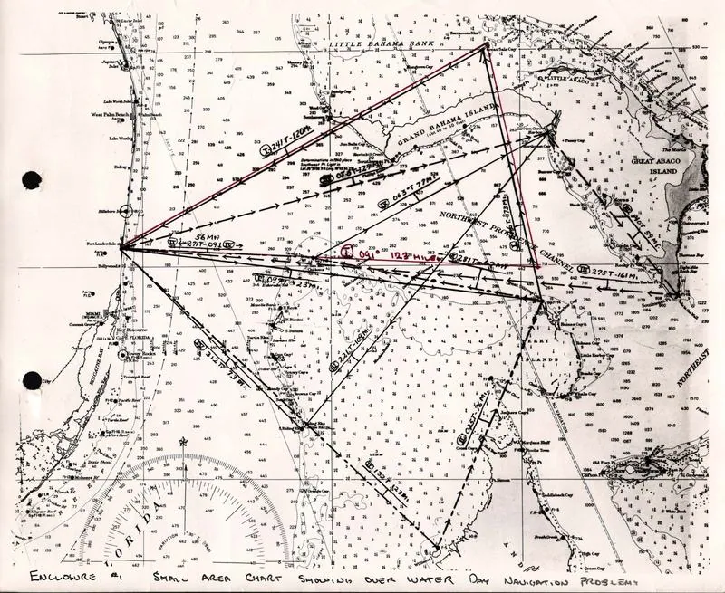
Chart of Navigation Problem No. 1, Flight 19's briefed route (1945): picture
The planned course the flight was to fly; the route on this record's map is computed from the same legs.
U.S. Navy, 1945. Public domain
Copies 3
ScanUS National Archives · catalog.archives.gov · Public domain (US government work)Primary source: Flight 19 Navigation Problem #11 step from the original
ScanU.S. Navy · commons.wikimedia.org · Public domain (US government work)2 steps from the original

PictureU.S. Navy · catalog.archives.gov · Public domain (US government work)1 step from the original
Where it was made
Flight 19's briefed route, Navigation Problem No. 1 · Flight route (as briefed, not as flown)
Sources 1
Cite it
Mysteries Department. (2026). Chart of Navigation Problem No. 1, Flight 19's briefed route (1945) [Artifact ART0D667FFR1N6W]. https://mysteriesdept.com/r/ART0D667FFR1N6W
@misc{mysteriesdept_art0d667ffr1n6w,
  title     = {Chart of Navigation Problem No. 1, Flight 19's briefed route (1945)},
  author    = {{Mysteries Department}},
  year      = {2026},
  note      = {Artifact, catalog key ART0D667FFR1N6W},
  url       = {https://mysteriesdept.com/r/ART0D667FFR1N6W}
}