The Bloop and NOAA's unexplained ocean sounds
The deep ocean carries low-frequency sound for thousands of kilometres through the SOFAR channel, a layer where temperature and pressure trap sound waves. From 1991 NOAA's Pacific Marine Environmental Laboratory (PMEL) used the US Navy's SOSUS hydrophones to listen for undersea earthquakes and eruptions, and from May 1996 it ran its own array of autonomous hydrophone moorings in the eastern equatorial Pacific for the same purpose[1][2]. Among the earthquakes, whales and ships, the analysts heard a handful of loud signals they could not place and gave them names.
The best known is the Bloop, a broadband sound recorded in the summer of 1997 and heard on sensors more than 5,000 km apart[3]. In 2002 a New Scientist report, relayed by CNN, said it bore the hallmarks of an animal but was louder than any known creature, and the idea of an unknown giant animal took hold in popular culture[4]. NOAA's own scientists had already suspected ice: in 2001 Christopher Fox of PMEL's acoustic monitoring project said it might be ice calving because "it always comes from the south"[5]. PMEL now describes the Bloop as consistent with icequakes from large icebergs cracking, based on the similarity of its spectrogram to icequakes recorded in the Scotia Sea and on its arrival direction[3]; NOAA's Ocean Service dates the identification to 2005[6].
The other named sounds have been assigned in the same way. Train, Slow Down and Julia are attributed to icebergs grounding on the seafloor; Whistle to an erupting volcano too distant to locate; Upsweep, the oldest and most persistent, remains unresolved on PMEL's own page[7][8][9][10][11]. The case is a good test of how far a spectrogram and a bearing can carry an attribution. The explanations are plausible and fit a body of peer-reviewed work showing that Antarctic ice is one of the loudest natural sources in the southern oceans[12][13][14]. But no paper has published the original 1990s recordings, their arrival times or their azimuths, so the specific attributions cannot be checked by anyone outside NOAA. Of the 5 questions on this site, 0 are answered. The most likely answer to “What made the loud unidentified sounds recorded by NOAA's Pacific hydrophones in the 1990s?”, not yet confirmed: all of them are natural geophysical or cryogenic sounds (icequakes, grounding icebergs, volcanic eruptions….
Key questionsset by the editors
What happened
PMEL began recording the Navy's SOSUS arrays in August 1991 and was using them to locate undersea eruptions by 1993[11][1]. In May 1996 it deployed its own array of autonomous hydrophones in the eastern equatorial Pacific, moored in the SOFAR channel to monitor the East Pacific Rise between 20°N and 20°S and the Galápagos Ridge; the array recorded continuously and was recovered and redeployed at intervals[2].
Upsweep was already present when SOSUS recording began in 1991: long trains of narrowband sounds rising in pitch over several seconds each, loud enough to be heard across the Pacific, peaking in spring and autumn[11]. In 1997 the equatorial array recorded Train on 4 March, a quasi-steady tone at 32 to 35 Hz[7]; Slow Down, a sound that descends in frequency over about seven minutes, in a file numbered for day 139 of 1997 (19 May)[8]; Whistle on 7 July, an undulating single tone on the hydrophone at 8°N 110°W[10]; and the Bloop, during the summer[3]. Julia followed on 1 March 1999 at 21:05 GMT[9].
Timeline
The accounts
There are no witnesses beyond the analysts and their recordings. The public record is a set of short PMEL web pages, one per sound, each with a spectrogram and an audio clip sped up 10 to 20 times so that infrasound becomes audible[3][11][7][9][10][8]. The pages are undated and have been revised. The Slow Down clip is still labelled "Equatorial Pacific unknown source" on the program's index page while the cryogenic page calls it an iceberg grounding[15][8].
Press accounts filled the gap. In June 2002 CNN, summarising New Scientist, described the Bloop as possibly a giant animal, quoted the marine biologist Phil Lobel doubting a squid but favouring a biological source, and quoted Fox that most of the named sounds had been explained, with Upsweep tracked to an undersea volcano[4]. The same report said the Bloop was heard on Navy SOSUS sensors 3,000 miles apart; NOAA's Ocean Service says hydrophones more than 3,219 km apart across the Pacific; neither names the instruments precisely[4][6]. NOAA's Ocean Service lists the theories that circulated: military exercises, ship engines, fishing-boat winches, giant squid, whales and unknown animals[6].
What was recorded
What survives in public is about a dozen sped-up audio files and spectrogram images, released as public information that may be freely redistributed with credit[16]. The Bloop clip is 16 times real speed; Upsweep 20 times; Whistle 16 times and band-passed between 8 and 20 Hz[3][11][10]. The raw multi-hydrophone recordings, the arrival-time picks and the azimuth estimates behind each attribution have not been published; no 1990s equatorial array data were found in NOAA's public passive acoustic archive[17].
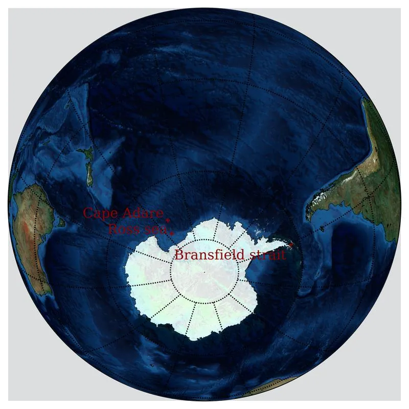
Two things about the sounds are stated with numbers. The Bloop was detected at ranges over 5,000 km and its bearing pointed between Bransfield Strait and the Ross Sea, or to Cape Adare[3]. Upsweep was located roughly at 54°S 140°W and has declined in level since 1991[11]. Whistle, heard on one hydrophone, cannot be located at all, because a fix needs at least three[10].
The explanations
Ice is the explanation NOAA gives for four of the six. The supporting work is strong on the general point. Hydrophones moored in the Scotia Sea recorded iceberg A53a, about 55 by 25 km, producing harmonic tremor as it scraped the seabed and short broadband icequakes as it broke up near South Georgia on 2 February 2008[18]. The breakup of icebergs C19a and B15a from late 2007 raised noise levels at mid to equatorial latitudes for about a year and a half, and seasonal noise cycles across the southern oceans track iceberg drift[12]. Ice tremor off Wilkes Land reaches estimated source levels near 245 dB[13], and Ross Sea icebergs were recorded as far away as French Polynesia in the same years[14][19]. PMEL's case for the Bloop is that its spectrogram resembles the Scotia Sea icequakes and its bearing points at Antarctic coasts known for ice sounds[3]. For Train and Julia the case is a steady or descending tone from the direction of the Ross Sea or the Antarctic Peninsula, which matches a berg dragging or settling on the seabed[7][9].
A biological source was the reading the press preferred for the Bloop. Its basis was the sound's rising frequency, which reminded biologists of animal calls, and its loudness, which no known animal approaches; it rests on no recording of any animal and no NOAA scientist has proposed it[4][5]. A human source (exercises, engines, winches) was suggested but fits poorly with a source to the far south at ranges over 5,000 km[6][3].
Upsweep has two readings. PMEL notes that its rough location lies near inferred volcanic seismicity but calls the origin unresolved; in 2002 Fox was reported as saying it had been tracked to an undersea volcano[11][4]. Its seasonality could reflect the source or seasonal changes in how sound travels[11]; seasonal ice noise is now documented across the southern oceans, which makes an ice component worth testing[12].
Published claims
| Year | Who | Claimed | Status | Reason |
|---|---|---|---|---|
| 1995 | Christopher Fox and colleagues (NOAA PMEL)[1] | The Navy's SOSUS hydrophone arrays can detect and locate a seafloor volcanic episode, as they did on the Juan de Fuca Ridge in 1993. | Accepted | The method became routine and led to the autonomous arrays that recorded the 1990s sounds[2]. |
| 2001 | Christopher Fox (NOAA PMEL)[5] | The Bloop may be related to ice calving, since it always comes from the south. | Still possible | The southern, Antarctic source held, but PMEL later attributed the sound to icequakes in cracking icebergs rather than calving from a shelf[3]. |
| 2002 | Phil Lobel, reported by New Scientist and CNN[4] | The Bloop's profile resembles a sound made by a living thing, though probably not a squid. | Disputed | Icequakes recorded near Antarctica later matched its spectrogram, and NOAA now identifies the sound as an icequake[3][6]. |
| 2002 | Christopher Fox (NOAA PMEL), reported by CNN[4] | The Upsweep has been tracked to an undersea volcano in the South Pacific. | Still possible | PMEL still calls its origin unresolved; the source lies near inferred volcanic seismicity, and an ice origin is also proposed[11][12]. |
| 2002 | Jacques Talandier, Olivier Hyvernaud, Emile Okal and Pierre-Franck Piserchia[14] | Large icebergs in the Ross Sea make hydroacoustic signals that seismic stations in French Polynesia record thousands of kilometres away. | Accepted | Replicated for other bergs in the Indian and Pacific oceans and in the Scotia Sea[19][18]. |
| 2005 | Emily Chapp, DelWayne Bohnenstiehl and Maya Tolstoy[13] | Drifting icebergs off Wilkes Land produce low-frequency tremor with source levels up to about 245 dB. | Accepted | Consistent with later iceberg recordings that show ice is loud enough to be heard across ocean basins[12]. |
| 2005 | NOAA PMEL acoustics researchers[6] | The Bloop was an icequake, made by a large iceberg cracking and fracturing off Antarctica. | Accepted | The 2008 recordings of iceberg A53a breaking up gave icequakes with similar spectrograms, heard at over 5,000 km[3][18]. |
| 2006 | Jacques Talandier, Olivier Hyvernaud, Dominique Reymond and Emile Okal[19] | Icebergs both grounded and drifting produce distinctive hydroacoustic signals recorded at long range in the southern oceans. | Accepted | Matches PMEL's attribution of Train and Julia to grounding icebergs, though those identifications rest on azimuth alone[7][9]. |
| 2013 | Robert Dziak and colleagues[18] | Iceberg A53a gave off harmonic tremor while scraping shoals and short broadband icequakes as it broke up near South Georgia in 2008. | Accepted | The first iceberg followed acoustically from drift to breakup, and the reference for identifying the Bloop[3]. |
| 2014 | Haruyoshi Matsumoto and colleagues[12] | Antarctic icebergs are a major source of ocean noise across the Southern Hemisphere, and seasonal noise cycles follow their drift and breakup. | Accepted | Shown with archived records of the breakup of bergs C19a and B15a; whether it also explains the Upsweep's seasonality has not been tested directly[12]. |
What would settle it
Release of the original multi-hydrophone records, with arrival times, for each named sound. With those, the bearings can be recomputed and compared with iceberg positions on the same dates from the scatterometer iceberg database, which covers 1997 through ERS and NSCAT and 1999 through ERS and QuikSCAT[20][21]. A classifier trained on modern labelled recordings of icequakes, groundings, tremor and eruptions could then score each 1990s sound against each class[17][18]. For Upsweep, a multi-year record from hydrophones south of 40°S would show whether the source is fixed (a vent) or moves with the ice.
Questions
0 of 5 questions are answered.
Evidence 29 findings
Artifacts
The films, photos, papers and objects this mystery rests on, each with its own key and its distance from the original.
See also
References
- 1.Fox, C., Radford, W., Dziak, R. et al. 1995. Acoustic detection of a seafloor spreading episode on the Juan de Fuca Ridge using military hydrophone arrays. Geophysical Research Letters 22(2): 131–134.doicited 2 times hereSRC0D9C739272G6
- 2.Fox, C., Matsumoto, H., Lau, T. 2001. Monitoring Pacific Ocean seismicity from an autonomous hydrophone array. Journal of Geophysical Research: Solid Earth 106(B3): 4183–4206.doicited 5 times hereSRC0D9C73182V9E
- 3.NOAA Pacific Marine Environmental Laboratory, A. n.d.. Acoustics Monitoring Program: Icequakes (Bloop). NOAA PMEL Acoustics Program (pmel.noaa.gov).cited 13 times hereSRC0D9C70TY0F01
- 4.CNN 2002. Tuning in to a deep sea monster. CNN.com, 13 June 2002.cited 9 times hereSRC0D9C75Q645CK
- 5.CNN 2001. Scientists tune in to sounds of the sea. CNN.com, 7 September 2001.cited 3 times hereSRC0D9C75FC7Z2D
- 6.NOAA National Ocean Service n.d.. What is the bloop?. NOAA Ocean Facts (oceanservice.noaa.gov).cited 5 times hereSRC0D9C72SE163B
- 7.NOAA Pacific Marine Environmental Laboratory, A. n.d.. Acoustics Monitoring Program: Iceberg Grounding (Train). NOAA PMEL Acoustics Program (pmel.noaa.gov).cited 7 times hereSRC0D9C71JC5TEP
- 8.NOAA Pacific Marine Environmental Laboratory, A. n.d.. Cryogenic (Ice) sounds. NOAA PMEL Acoustics Program (pmel.noaa.gov).cited 10 times hereSRC0D9C72202TZM
- 9.NOAA Pacific Marine Environmental Laboratory, A. n.d.. Acoustics Monitoring Program: Iceberg Grounding on Seafloor (Julia). NOAA PMEL Acoustics Program (pmel.noaa.gov).cited 7 times hereSRC0D9C71AJ57W0
- 10.NOAA Pacific Marine Environmental Laboratory, A. n.d.. Acoustics Monitoring Program: Submarine Volcanic Eruption (Whistle). NOAA PMEL Acoustics Program (pmel.noaa.gov).cited 9 times hereSRC0D9C71T62YG9
- 11.NOAA Pacific Marine Environmental Laboratory, A. n.d.. Acoustics Monitoring Program: Upsweep. NOAA PMEL Acoustics Program (pmel.noaa.gov).cited 15 times hereSRC0D9C712R2AJY
- 12.Matsumoto, H., Bohnenstiehl, D., Tournadre, J. et al. 2014. Antarctic icebergs: A significant natural ocean sound source in the Southern Hemisphere. Geochemistry, Geophysics, Geosystems 15(8): 3448–3458.doicited 5 times hereSRC0D9C73RP5QGT
- 13.Chapp, E., Bohnenstiehl, D., Tolstoy, M. 2005. Sound-channel observations of ice-generated tremor in the Indian Ocean. Geochemistry, Geophysics, Geosystems 6(6).doicited 2 times hereSRC0D9C740G37ZY
- 14.Talandier, J., Hyvernaud, O., Okal, E. et al. 2002. Long-range detection of hydroacoustic signals from large icebergs in the Ross Sea, Antarctica. Earth and Planetary Science Letters 203(1): 519–534.doicited 2 times hereSRC0D9C748A3W90
- 15.NOAA Pacific Marine Environmental Laboratory, A. n.d.. Acoustic Monitoring Program: Sounds (examples). NOAA PMEL Acoustics Program (pmel.noaa.gov).cited 3 times hereSRC0D9C729T1MG7
- 16.NOAA Pacific Marine Environmental Laboratory, A. n.d.. NOAA PMEL Acoustics Program: Multimedia and credits. NOAA PMEL Acoustics Program (pmel.noaa.gov).cited 2 times hereSRC0D9C72HM17HH
- 17.NOAA National Centers for Environmental Information n.d.. Passive Acoustic Data. NOAA NCEI.cited 2 times hereSRC0D9C757J6A7Q
- 18.Dziak, R., Fowler, M., Matsumoto, H. et al. 2013. Life and Death Sounds of Iceberg A53a. Oceanography 26(2).doicited 8 times hereSRC0D9C73GW1MV0
- 19.Talandier, J., Hyvernaud, O., Reymond, D. et al. 2006. Hydroacoustic signals generated by parked and drifting icebergs in the Southern Indian and Pacific Oceans. Geophysical Journal International 165(3): 817–834.doicited 3 times hereSRC0D9C74G44MTQ
- 20.Budge, J., Long, D. 2018. A Comprehensive Database for Antarctic Iceberg Tracking Using Scatterometer Data. IEEE Journal of Selected Topics in Applied Earth Observations and Remote Sensing 11(2): 434–442.doicited 1 time hereSRC0D9C74QY45DF
- 21.Budge, J., Vorwaller, S., Cribs, K. et al. n.d.. The Antarctic Iceberg Tracking Database (1978 & 1992–present). Brigham Young University, Microwave Earth Remote Sensing Laboratory (scp.byu.edu).cited 2 times hereSRC0D9C74ZR5AEZ