The Nazca Lines
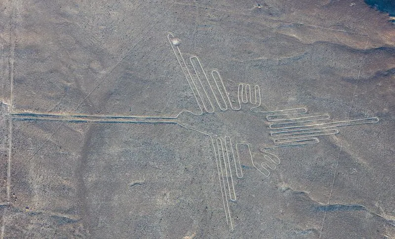
The Nazca Lines cover the stony desert plateau between the Ingenio and Nazca rivers, 400 km south of Lima. They are of three kinds: straight lines, some several kilometres long, that radiate from about 62 low hills and rises the surveyors call line centres; cleared trapezoids and rectangles; and figures, from the giant hummingbird, monkey and spider 50 to 300 m long to small figures of a few metres cut into hillsides[1][2]. All were made the same way, by lifting the dark, iron-stained surface stones and piling them at the edges to expose the paler ground, a technique that needs no more than cords, stakes and labour and that survives because the pampa is one of the driest places on earth[3].
The makers are known from the pottery left on the lines and from excavations in the valleys. The hillside figures belong to the Paracas culture of the later first millennium BC; the pampa lines and the famous animal figures belong to the Nasca culture, dated by radiocarbon at Palpa to about 200 BC to AD 650, with some lines reused and added later[4][5]. The 1980s survey led by Anthony Aveni mapped the line centres and showed that the lines were walked, link to one another and to water courses, and do not point to the sky in any pattern beyond chance[1][6].
What the lines were for is the question that remains. In 2024 Masato Sakai's team at Yamagata University, with IBM, used an AI detector on high-resolution imagery and then field-checked candidates, finding 303 new figurative geoglyphs in six months and nearly doubling the known total[2]. The enlarged catalogue let them show that the small relief-type figures, mostly humans, domesticated animals and severed heads, lie beside footpaths and were meant to be seen by people walking, while the giant line-type figures, mostly wild animals, lie beside the network of ceremonial lines and trapezoids and were made at community scale[2]. A further 248 geoglyphs were announced in August 2025[7]. Of the 4 questions on this site, 2 are answered. The most likely answer to “What were the Nazca Lines for?”, not yet confirmed: the lines were made and walked in rites concerned with water and fertility, linking line centres, valleys and….
Key questionsset by the editors
The site
The pampa is a plateau of alluvial gravel whose stones have a dark desert varnish; beneath lies pale, lighter sediment. Removing the stones leaves a line visible for centuries in the absence of rain and wind erosion[3]. The lines are best seen from the air, which drove the earliest speculation, but the surveys show every figure and line can be laid out from the ground with simple methods and that the lines were made to be walked: they are bordered by stone heaps, worn paths run along them, and a 4.4 km labyrinth recorded by Ruggles and Saunders can only be understood by following it[1][8].
The Nasca lived in the valleys that cut the desert, where water runs only part of the year. They built puquios, underground aqueducts with spiral entrances, to reach groundwater; many survive in use[9]. Their ceremonial centre, Cahuachi, a complex of adobe mounds on the south bank of the Nazca river, faces the pampa and is reached by lines from it[10]. The World Heritage site, inscribed in 1994, covers the pampa and the Palpa valleys[11].
Timeline
What was found
Aveni's teams mapped 62 line centres from which some 800 straight lines radiate, recorded the pottery on them, and walked them; the lines link centres to one another and tend to run toward water courses and along the axes of the valleys[1][3]. Ruggles tested the azimuths of the radial lines against the sun, moon and stars and found no significant pattern beyond a weak solstitial tendency[6]. Silverman and Browne dated the Ingenio valley lines by the pottery on them to the Nasca phases, with Paracas hillside figures earlier[4]. At Palpa, the German Archaeological Institute's project dated the sequence by AMS radiocarbon and documented the hillside figures with photogrammetry[5].
Geophysical and geochemical measurements across lines and off them at Nasca and Palpa found no systematic difference in the ground beneath, which tells against the reading that the lines mark faults or buried water courses[12].
Sakai's group trained a deep-learning model on the known relief-type figures, which are small and hard to see, and used it to rank the whole pampa for field survey; four new figures were confirmed in 2023 and 303 in 2024, bringing the figurative total to 733[13][2]. Of the relief-type figures, 81.6 per cent show humans or things humans had modified, such as llamas and trophy heads, and they sit on average 43 m from ancient trails; of the giant line-type figures, 64 per cent show wild animals, and they sit on average 34 m from the ceremonial line network[2]. By August 2025 the team had added 248 more, including 41 human figures, 31 decapitation scenes and 21 llamas, arranged by theme along small paths, for a figurative total of 893[7].
What is known
The method is settled by the surveys and by the stone heaps and paths; nothing about the lines requires technology beyond what the Nasca had[3][1]. The date is settled to the Paracas and Nasca periods by the associated pottery and the Palpa radiocarbon sequence[4][5]. The lines were walked, and the straight lines connect centres, the valleys and water[1][8]. Astronomical alignment is not a general property of the lines[6].
The pampa's figures are now catalogued at a scale that permits statistics, and the 2024 study is the first to show a difference in motif and placement between small and giant figures that bears on who made them and for whom[2]. The site is under pressure from informal mining and from traffic; in June 2025 the Peruvian government cut the 5,600 km² protected zone by 42 per cent to open permits and reversed the cut within days after objection[14].
The explanations
The astronomical calendar, Maria Reiche's reading, holds that lines point to solstice and other risings and that figures are constellations. Hawkins's 1968 test and Ruggles's statistics found no more alignments than chance; the reading survives only for a handful of lines[15][6].
The water reading comes in two forms. One, from the 1980s survey, is that the lines were made and walked in rites concerned with water and fertility, since they run to and along water courses and the Nasca lived at the limit of irrigation; it is consistent with the line centres, the paths and the puquios[1][9]. The other, that lines physically mark aquifers or faults below, was tested by geophysics and not supported[12].
The ritual-path reading, that lines and trapezoids were processional routes, with Cahuachi as the pilgrimage destination, fits the paths, the labyrinth and the position of the giant figures beside the line network[10][8][2]. The 2024 study adds a second scale: small figures beside footpaths were for individuals or small groups passing, and their motifs, humans, llamas and trophy heads, differ from the wild animals of the community-scale figures[2].
Published claims
| Year | Who | Claimed | Status | Reason |
|---|---|---|---|---|
| 1949 | Maria Reiche[16] | The lines are an astronomical calendar: they point to solstice and other risings, and the figures stand for constellations. | Disputed | Statistical tests of the line directions found no more astronomical alignments than chance, apart from a weak solstitial tendency[6][15] |
| 1968 | Erich von Däniken[17] | The lines were laid out for, or copied from, the airfields of extraterrestrial visitors. | Disputed | Archaeologists reject it: the lines are shallow, made with hand tools by moving surface stones, walked, and dated by the Nasca pottery on them[3][15] |
| 1990 | Anthony Aveni[1] | The lines radiate from 62 line centres, link to water courses and were walked, in rites concerned with water and fertility. | Most likely | The survey's pattern holds and fits the Nasca water works, but what the rites were cannot be read from the ground alone[9] |
| 1990 | Clive Ruggles[6] | The azimuths of the radial lines show no significant astronomical pattern beyond a weak solstitial tendency. | Accepted | No later statistical study has found a stronger astronomical pattern[15] |
| 1990 | Persis Clarkson[3] | The geoglyphs were made from the ground by moving the dark surface stones, and the pottery on them is mostly Nasca. | Accepted | Excavation, ceramic dating and the AMS chronology agree[4][5] |
| 1990 | Helaine Silverman[10] | Cahuachi was a pilgrimage centre, and the lines were paths of ritual movement across the pampa toward it. | Most likely | The walked labyrinth and the placing of the giant figures beside the line network fit it, but it remains an interpretation of the paths, not a tested result[8][2] |
| 1991 | Helaine Silverman and David Browne[4] | Pottery on the lines dates them mainly to the Nasca period, with earlier Paracas figures on hillsides and later use. | Accepted | AMS dates from the Palpa excavations fix the Nasca period at about 200 BC to AD 650[5] |
| 2000 | Stephen Mabee, Donald Proulx, David Johnson and colleagues[18] | Some geoglyphs mark underground water sources, springs and aquifers fed along faults. | Disputed | Geophysical and geochemical measurements on and off the lines found no systematic difference beneath them[12] |
| 2007 | Ingmar Unkel, Bernd Kromer, Markus Reindel and Lukas Wacker[5] | AMS radiocarbon dates fix the Paracas culture at about 800 to 200 BC and the Nasca at about 200 BC to AD 650. | Accepted | The chronology agrees with the ceramic dating of the lines and has not been challenged[4] |
| 2009 | Kerstin Hartsch, Andreas Weller and colleagues[12] | There is no geophysical or geochemical evidence that the lines mark faults or water-bearing structures below. | Accepted | No later measurement has found the contrast the aquifer reading predicts[12] |
| 2012 | Clive Ruggles and Nicholas Saunders[8] | A 4.4 km labyrinth of lines on the pampa was a path meant to be walked, not a picture to be seen from above. | Most likely | It fits the paths worn along the lines and the walking reading of the line centres[1] |
| 2023 | Masato Sakai and colleagues[13] | A deep-learning detector trained on known relief figures can find new geoglyphs, four of which were confirmed in the field. | Accepted | The method found 303 more figures in the next survey[2] |
| 2024 | Masato Sakai and colleagues[2] | Small relief figures were made beside footpaths for people passing, while the giant line figures sit beside the ritual line network. | Most likely | The distances to trails and to the line network are measured on 303 new figures, but the catalogue keeps growing and is not open for reanalysis[7] |
What would settle it
Purpose will not be settled by one test, but the readings now make different predictions about placement and motif that the full catalogue can check: whether the giant figures cluster at line centres and along routes to Cahuachi, whether small figures follow the trails that link settlements, and whether motif themes along a path form sequences[2]. Excavation at line centres and along trapezoids for offerings, pottery and dated organic matter would tie individual lines to phases and to events[3]. Publication of the 2025 finds with coordinates and dates, and an open catalogue of all geoglyphs, would let others test the claims[7].
Questions
2 of 4 questions are answered.
Evidence 13 findings
Artifacts
The films, photos, papers and objects this mystery rests on, each with its own key and its distance from the original.
See also
References
- 1.Aveni, A. 1990. Order in the Nazca Lines. The Lines of Nazca (American Philosophical Society, Memoirs 183).doicited 7 times hereSRC0CT6X41R5BYA
- 2.Sakai, M., Sakurai, A., Lu, S. et al. 2024. AI-accelerated Nazca survey nearly doubles the number of known figurative geoglyphs and sheds light on their purpose. Proceedings of the National Academy of Sciences.doicited 14 times hereSRC0CT6X6FW264V
- 3.Clarkson, P. 1990. The Archaeology of the Nazca Pampa: Environmental and Cultural Parameters. The Lines of Nazca (American Philosophical Society, Memoirs 183).doicited 4 times hereSRC0CT6X49J68MS
- 4.Silverman, H., Browne, D. 1991. New evidence for the date of the Nazca lines. Antiquity.doicited 5 times hereSRC0CT6X51029RT
- 5.Unkel, I., Kromer, B., Reindel, M. et al. 2007. A Chronology of the Pre-Columbian Paracas and Nasca Cultures in South Peru Based on AMS 14C Dating. Radiocarbon.doicited 6 times hereSRC0CT6X58T654P
- 6.Ruggles, C. 1990. A Statistical Examination of the Radial Line Azimuths at Nazca. The Lines of Nazca (American Philosophical Society, Memoirs 183).doicited 3 times hereSRC0CT6X4S60J3Q
- 7.Andina 2025. Japanese researchers unveil 248 new Peruvian Nasca Lines geoglyphs. Agencia Andina (Peruvian state news agency).cited 6 times hereSRC0CT6X6QP5Z51
- 8.Ruggles, C., Saunders, N. 2012. Desert labyrinth: lines, landscape and meaning at Nazca, Peru. Antiquity.doicited 3 times hereSRC0CT6X5RE23ED
- 9.Lasaponara, R., Lancho Rojas, J., Masini, N. 2016. Puquios: The Nasca Response to Water Shortage. The Ancient Nasca World (Springer).doicited 2 times hereSRC0CT6X6082A2R
- 10.Silverman, H. 1990. The Early Nasca Pilgrimage Center of Cahuachi and the Nazca Lines: Anthropological and Archaeological Perspectives. The Lines of Nazca (American Philosophical Society, Memoirs 183).doicited 4 times hereSRC0CT6X4HC5F3Y
- 11.UNESCO World Heritage Centre 1994. Lines and Geoglyphs of Nasca and Palpa. UNESCO World Heritage List.cited 2 times hereSRC0CT6X77A2WYN
- 12.Hartsch, K., Weller, A., Rosas, S. et al. 2009. The Nasca and Palpa geoglyphs: geophysical and geochemical data. Naturwissenschaften.doicited 3 times hereSRC0CT6X5GM1RT5
- 13.Sakai, M., Lai, Y., Olano Canales, J. et al. 2023. Accelerating the discovery of new Nasca geoglyphs using deep learning. Journal of Archaeological Science.doicited 1 time hereSRC0CT6X6820N4V
- 14.Grattan, S. 2025. Peru reinstates full protection of Nazca Lines reserve after controversial cutback. Associated Press (via CP24).cited 3 times hereSRC0CT6X6ZG3G58
- 15.Aveni, A. 1990. An Assessment of Previous Studies of the Nazca Geoglyphs. The Lines of Nazca (American Philosophical Society, Memoirs 183).doicited 4 times hereSRC0CT6X3SY2NF9
- 16.Reiche, M. 1949. Mystery on the Desert: A New Revelation of Ancient Peru. Book (the catalogue entry read gives no publisher).cited 1 time hereSRC0CT6X7YR3HYF
- 17.Däniken, E. 1968. Erinnerungen an die Zukunft: Ungelöste Rätsel der Vergangenheit (Chariots of the Gods?). Econ-Verlag.cited 1 time hereSRC0CT6X86J4Q7T
- 18.University of Massachusetts Amherst 2000. Peru's Nasca Lines Point To Water Sources, Suggest UMass Researchers. ScienceDaily, 1 December 2000.cited 1 time hereSRC0CT6X8EC1TDB